IMAGES TAKEN NEAR TO
Goats Gate Terrace, Cromwell Road, MANCHESTER, M45 7RS
Introduction
This page details the photographs taken nearby to Goats Gate Terrace, Cromwell Road, M45 7RS by members of the Geograph project.
The Geograph project started in 2005 with the aim of publishing, organising and preserving representative images for every square kilometre of Great Britain, Ireland and the Isle of Man.

There are currently over 7.5m images from over14,400 individuals and you can help contribute to the project by visiting https://www.geograph.org.uk
Image Map
Images are licensed for reuse under creativecommons.org/licenses/by-sa/2.0
Notes
- Clicking on the map will re-center to the selected point.
- The higher the marker number, the further away the image location is from the centre of the postcode.
Image Listing (32 Images Found)
Images are licensed for reuse under creativecommons.org/licenses/by-sa/2.0
Image
Details
Distance
3
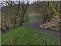
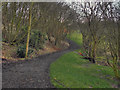
Springwater Park
The footpath through Springwater Park
Image: © David Dixon
Taken: 10 Jan 2012
0.09 miles
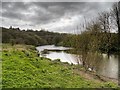
6

Fast-flowing Stream in Springwater Park
This stream (which presumably collects excess rainwater) flows down the hill and drains into the River Irwell below,
Image: © David Dixon
Taken: 10 Nov 2020
0.10 miles
7
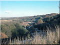
Wooded valley
Looking north east across a meander in the river Irwell. On the left of the picture, hidden by trees, is a large area of landfill.
Image: © Dennis Turner
Taken: 18 Nov 2005
0.11 miles

10
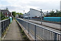
Leicester Road, Whitefield
Ahead is the Polyflor factory. In the foreground is a bridge over the Metrolink line between Whitefield and Radcliffe.
Image: © Bill Boaden
Taken: 26 Jul 2011
0.14 miles