IMAGES TAKEN NEAR TO
Ryecroft, MANCHESTER, M45 7HZ
Introduction
This page details the photographs taken nearby to Ryecroft, M45 7HZ by members of the Geograph project.
The Geograph project started in 2005 with the aim of publishing, organising and preserving representative images for every square kilometre of Great Britain, Ireland and the Isle of Man.

There are currently over 7.5m images from over14,400 individuals and you can help contribute to the project by visiting https://www.geograph.org.uk
Image Map
Images are licensed for reuse under creativecommons.org/licenses/by-sa/2.0
Notes
- Clicking on the map will re-center to the selected point.
- The higher the marker number, the further away the image location is from the centre of the postcode.
Image Listing (7 Images Found)
Images are licensed for reuse under creativecommons.org/licenses/by-sa/2.0
Image
Details
Distance
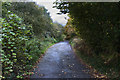
1
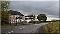
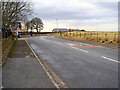
Old Hall Lane
250 yards after leaving Ringley Road, Old Hall Lane Image]changes to a track whilst the road bends to the left and becomes Sergeants Lane.
Image: © David Dixon
Taken: 6 Mar 2010
0.04 miles
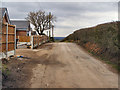
5
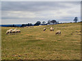
Farmland off Old Hall Lane
Sheep grazing in the field off Ringley Road and Old Hall Lane at Stand.
Image: © David Dixon
Taken: 6 Mar 2010
0.18 miles