IMAGES TAKEN NEAR TO
Westlands, MANCHESTER, M45 7HH
Introduction
This page details the photographs taken nearby to Westlands, M45 7HH by members of the Geograph project.
The Geograph project started in 2005 with the aim of publishing, organising and preserving representative images for every square kilometre of Great Britain, Ireland and the Isle of Man.

There are currently over 7.5m images from over14,400 individuals and you can help contribute to the project by visiting https://www.geograph.org.uk
Image Map
Images are licensed for reuse under creativecommons.org/licenses/by-sa/2.0
Notes
- Clicking on the map will re-center to the selected point.
- The higher the marker number, the further away the image location is from the centre of the postcode.
Image Listing (28 Images Found)
Images are licensed for reuse under creativecommons.org/licenses/by-sa/2.0
Image
Details
Distance
2
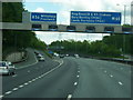
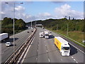
Approaching Junction 17 M60 - Prestwich
Image: © Anthony Parkes
Taken: 2 Mar 2011
0.10 miles
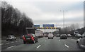
3
Whitefield : M60 Motorway
The M60 motorway between Junction 17 (Whitefield Interchange) and Junction 16.
Image: © Lewis Clarke
Taken: 27 Sep 2019
0.13 miles
4
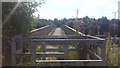
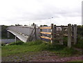
Footpath over the M60, Whitefield
The bridge is located near to Whitefield Golf Course and Junction 17 of the M60. It is a public footpath with a link to Philips Park.
Image: © Bradley Michael
Taken: 1 Sep 2016
0.14 miles
5
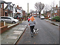
Midday walk, Pine Avenue
A break in the clouds gave an opportunity for a quick walk to the next square.
Image: © Jonathan Wilkins
Taken: 25 Dec 2012
0.18 miles
6
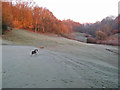
Sunrise over Hole Bottom
The steeply-incised headwaters of the Bradley Brook form a dell with wooded slopes, now within the Whitefield Golf Course. The rising sun is just tickling the tree-tops with a warm glow.
Image: © Jonathan Wilkins
Taken: 26 Dec 2013
0.20 miles
7
Footbridge
Bridge over the M60 motorway carrying a footpath that links Whitefield and Prestwich
Image: © Keith Williamson
Taken: 19 Sep 2006
0.21 miles
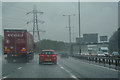
8
M60
Looking west into the Irwell valley along the M60 motorway from a footbridge between Prestwich and Whitefield. This section of the Manchester orbital motorway carries trans-pennine traffic as it links the eastern and western sections of the M62 motorway
Image: © Keith Williamson
Taken: 19 Sep 2006
0.21 miles
9
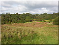
The Rough
Land at the southern edge of Whitefield Golf course by the M60 motorway.
Image: © Keith Williamson
Taken: 19 Sep 2006
0.21 miles
10
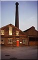
Prestwich Hospital boiler house.
This was highly visible beside the M60/M62 and the grid reference is approximate as it was demolished in 2005. We called in on the way home from Bradford and found coal fired Lancashire boilers in steam. The coal is behind the boards on the right. Gorgeous round brick chimney.
Image: © Chris Allen
Taken: 5 Jul 1987
0.21 miles