IMAGES TAKEN NEAR TO
Sandgate Road, MANCHESTER, M45 6WG
Introduction
This page details the photographs taken nearby to Sandgate Road, M45 6WG by members of the Geograph project.
The Geograph project started in 2005 with the aim of publishing, organising and preserving representative images for every square kilometre of Great Britain, Ireland and the Isle of Man.

There are currently over 7.5m images from over14,400 individuals and you can help contribute to the project by visiting https://www.geograph.org.uk
Image Map
Images are licensed for reuse under creativecommons.org/licenses/by-sa/2.0
Notes
- Clicking on the map will re-center to the selected point.
- The higher the marker number, the further away the image location is from the centre of the postcode.
Image Listing (19 Images Found)
Images are licensed for reuse under creativecommons.org/licenses/by-sa/2.0
Image
Details
Distance

4
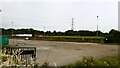
Car park for football ground
The home of Prestwich Heys on Sandgate Road
Image: © Kevin Waterhouse
Taken: 7 Sep 2023
0.11 miles
5
Haweswater Aqueduct
The aqueduct from Haweswater, in the Lake District, to Manchester terminates here at Heaton Park Reservoir. The aqueduct is 82 miles long, was finished in 1955 and carries up to 100 million gallons per day under gravity induced flow. The bas relief on the wall of this building depicts the pipeline. The plaques below the relief detail significant facts concerning its planning and construction. The Haweswater dam is here Image
Image: © Keith Williamson
Taken: 6 Oct 2005
0.17 miles

7

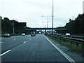
Whitefield : M60 Motorway
The M60 motorway between Junction 18 (Simister Interchange) and Junction 17 (Whitefield Interchange).
Image: © Lewis Clarke
Taken: 27 Sep 2019
0.19 miles
8

The M60 Motorway, Whitefield
Looking south west from the bridge on Sandgate Road.
Image: © JThomas
Taken: 10 Sep 2018
0.19 miles
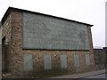
10
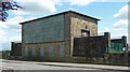
Terminal Building, Heywood Road, Manchester
Housing the mechanisms which control the influx of water from Haweswater to the reservoir in Heaton Park, a distance of around 80 miles. Built in 1955 by the City Engineers under Alan Atkinson and the City Architects under L.C. Howitt. "As the visible sign of a largely invisible but mighty undertaking, it has been given a monumental character." The wall has a large relief by Mitzi Cunliffe in Lake District slate (Image]) and five smaller panels depicting various aspects of this mighty undertaking. Grade II listed.
Image: © Stephen Richards
Taken: 24 May 2016
0.20 miles