IMAGES TAKEN NEAR TO
Bury New Road, MANCHESTER, M45 6QJ
Introduction
This page details the photographs taken nearby to Bury New Road, M45 6QJ by members of the Geograph project.
The Geograph project started in 2005 with the aim of publishing, organising and preserving representative images for every square kilometre of Great Britain, Ireland and the Isle of Man.

There are currently over 7.5m images from over14,400 individuals and you can help contribute to the project by visiting https://www.geograph.org.uk
Image Map
Images are licensed for reuse under creativecommons.org/licenses/by-sa/2.0
Notes
- Clicking on the map will re-center to the selected point.
- The higher the marker number, the further away the image location is from the centre of the postcode.
Image Listing (124 Images Found)
Images are licensed for reuse under creativecommons.org/licenses/by-sa/2.0
Image
Details
Distance
1
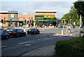
Morrisons in Whitefield
A strategic position on the corner of Bury New Road and Church Lane.
Image: © Bill Boaden
Taken: 26 Jul 2011
0.02 miles
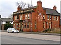
2
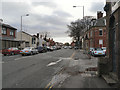
Whitefield, Bury New Road
Looking south, along the A56, near the junction with Moss Lane and Pinfold Lane.
Image: © David Dixon
Taken: 23 Dec 2012
0.02 miles
3
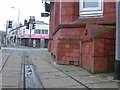
Whitefield, milestone
Unusual terracotta milestone attached to the old Red King pub, at the junction of Bury New Road & Moss Lane. Legend reads WHITEFIELD//To/RADCLIFFE/BRIDGE./1 MILE/&/1100 YARDS/(arrow)//To/MANCHESTER/TOWN HALL./5 MILES/&/500 YARDS/(arrow)//To BURY 31/2 MILES. Presumably built with the pub, perhaps architect's whimsy.
Image: © Mike Faherty
Taken: 26 Jan 2009
0.03 miles
4
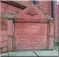
Old Milestone by the A665, Bury New Road, Bury parish
Carved stone plaque by the A665, in parish of BURY (BURY District), Bury New Road, attached to old Red King pub, No. 158-162, on East side of road. Erected by a private company in the 19th century.
Inscription reads:-
: To / RADCLIFFE / BRIDGE. / 1 MILE / & / 1100 YARDS / {<-arrow} : : WHITEFIELD : : To / MANCHESTER / TOWN HALL. / 5 MILES / & / 500 YARDS / {arrow->} : : TO BURY 3½ MILES. :
Listed.
Milestone Society National ID: LA_MABY05
Image: © Mike Faherty
Taken: 26 Jan 2009
0.03 miles
5
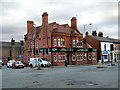
The Old Red King
This large red-brick building, now offices for a firm of surveyors at the junction of Moss Lane and Bury New Road, was once a public house. The windows carry the inscription "The Old Red King" and the pub sign board still hangs outside carrying the name "Red King" (Image]).
Image: © David Dixon
Taken: 23 Dec 2012
0.03 miles
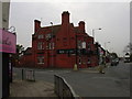
6
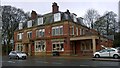
New Grove Inn
The corner of Bury New Road and Pinfold Lane.
Image: © David Dixon
Taken: 6 Mar 2010
0.03 miles
8
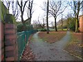
Parkland at Whitefield
Parkland leading to the ruins of the former Whitefield Town Hall.
Image: © Gerald England
Taken: 29 Dec 2018
0.04 miles
9
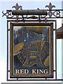
Red King
Sign hanging outside the former Red King public house (Image]) at the corner of Moss Lane and Bury New Road in Whitefield.
Image: © David Dixon
Taken: 23 Dec 2012
0.04 miles
10
Slattery's
Slattery's is a gourmet bakery and chocolate shop occupying 197 Bury New Road, in Whitefield, Greater Manchester, England. It is a landmark in Whitefield and draws customers from miles around.
Image: © Steven Haslington
Taken: 15 Apr 2015
0.04 miles