IMAGES TAKEN NEAR TO
Sharp Street, MANCHESTER, M4 4BZ
Introduction
This page details the photographs taken nearby to Sharp Street, M4 4BZ by members of the Geograph project.
The Geograph project started in 2005 with the aim of publishing, organising and preserving representative images for every square kilometre of Great Britain, Ireland and the Isle of Man.

There are currently over 7.5m images from over14,400 individuals and you can help contribute to the project by visiting https://www.geograph.org.uk
Image Map
Images are licensed for reuse under creativecommons.org/licenses/by-sa/2.0
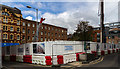
Notes
- Clicking on the map will re-center to the selected point.
- The higher the marker number, the further away the image location is from the centre of the postcode.
Image Listing (417 Images Found)
Images are licensed for reuse under creativecommons.org/licenses/by-sa/2.0
Image
Details
Distance
1
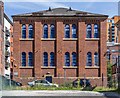
Manchester, ragged school
Sharp Street Ragged School, dated 1853 and one of two such buildings surviving in the area, once serving children in Angel Meadow; now residential, and far from poor. http://www.ragged-online.com/2014/09/history-ragged-schools-free-education-angel-meadows-manchester/
Image: © Mike Faherty
Taken: 24 Dec 2014
0.01 miles
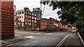
2
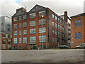
Angel Meadows
Commercial buildings converted to flats near Angel Meadows Park.
Image: © Peter McDermott
Taken: 5 Jul 2014
0.02 miles
3

Cooperative Printing Society Ltd
The old goods entrance to the Cooperative Printing Society Ltd on School Street.
Image: © Peter McDermott
Taken: 25 Jun 2017
0.02 miles
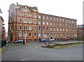
4
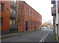
CWS Tobacco Factory
The front of the former CWS tobacco factory on Naples Street. Although it still carries the CWS name, the factory has been converted into an apartment complex.
Image: © David Dixon
Taken: 24 Feb 2012
0.02 miles
5

Halo
The 'Halo' development between School Street and New Mount Street.
Image: © Peter McDermott
Taken: 25 Jun 2017
0.02 miles
6
Angel Meadows
Part of the Angel Meadows development on Old Mount Street.
Image: © Peter McDermott
Taken: 23 Mar 2019
0.03 miles
7
Halo
The Halo development, a 6 storey residential development comprising of 66 one, two and three bed apartments with basement car parking.
Image: © Peter McDermott
Taken: 1 May 2017
0.04 miles
8
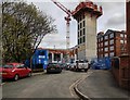
Mount Yard
The site of the new "Mount Yard" development, part of the wider development around Angel meadows.
Image: © Peter McDermott
Taken: 2 Sep 2018
0.04 miles
9
Manchester, CWS Printing Works
On New Mount Street, later transferring to Longsight; now residential and business units. http://manchesterhistory.net/manchester/tours/tour12/coopprint.html
Image: © Mike Faherty
Taken: 26 Dec 2014
0.04 miles
10
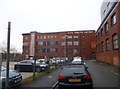
Manchester, CWS Tobacco Factory
On Ludgate Hill; now residential.
Image: © Mike Faherty
Taken: 26 Dec 2014
0.05 miles