IMAGES TAKEN NEAR TO
Cranford Drive, MANCHESTER, M44 6WT
Introduction
This page details the photographs taken nearby to Cranford Drive, M44 6WT by members of the Geograph project.
The Geograph project started in 2005 with the aim of publishing, organising and preserving representative images for every square kilometre of Great Britain, Ireland and the Isle of Man.

There are currently over 7.5m images from over14,400 individuals and you can help contribute to the project by visiting https://www.geograph.org.uk
Image Map
Images are licensed for reuse under creativecommons.org/licenses/by-sa/2.0
Notes
- Clicking on the map will re-center to the selected point.
- The higher the marker number, the further away the image location is from the centre of the postcode.
Image Listing (16 Images Found)
Images are licensed for reuse under creativecommons.org/licenses/by-sa/2.0
Image
Details
Distance
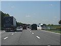
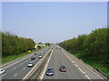
6
Irlam : M62 Motorway
Heading along the M62 between Junction 12 (Eccles Interchange) and Junction 11 (Birchword).
Image: © Lewis Clarke
Taken: 27 Sep 2019
0.15 miles
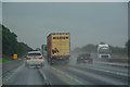
7
M62, Irlam
Looking west from the bridge at Cutnook Lane. On the far side, PN06AZG, a Scania P310 belonging to Olympic Foods of Liverpool.
Image: © David Dixon
Taken: 6 May 2014
0.15 miles
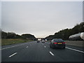
9
M62, Irlam, Salford
Here the M62 Motorway cuts across Irlam Moss just to the north of the town. Photo taken from SJ 719 953, looking NE in the direction of Manchester.
Image: © Keith Williamson
Taken: 24 Apr 2005
0.17 miles