IMAGES TAKEN NEAR TO
Buttermill Close, MANCHESTER, M44 6TF
Introduction
This page details the photographs taken nearby to Buttermill Close, M44 6TF by members of the Geograph project.
The Geograph project started in 2005 with the aim of publishing, organising and preserving representative images for every square kilometre of Great Britain, Ireland and the Isle of Man.

There are currently over 7.5m images from over14,400 individuals and you can help contribute to the project by visiting https://www.geograph.org.uk
Image Map
Images are licensed for reuse under creativecommons.org/licenses/by-sa/2.0
Notes
- Clicking on the map will re-center to the selected point.
- The higher the marker number, the further away the image location is from the centre of the postcode.
Image Listing (9 Images Found)
Images are licensed for reuse under creativecommons.org/licenses/by-sa/2.0
Image
Details
Distance
1
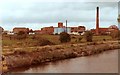
Manchester Ship Canal at CWS Margarine Works, Irlam
Image: © Colin Pyle
Taken: Unknown
0.09 miles
2
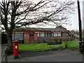
Irlam Library, Irlam, Manchester
Situated by Hurst's Fold, close to the centre of old Irlam village. SJ727952
Image: © Keith Williamson
Taken: 13 Apr 2005
0.11 miles
3
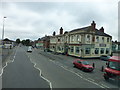
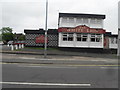
The Nags Head on Liverpool Road, Irlam
Image: © Raymond Knapman
Taken: 5 Aug 2014
0.12 miles
4
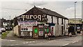
Irlam
Building in Irlam with "Turog, Best Brown Bread" sign.
Image: © Peter McDermott
Taken: 14 Jun 2017
0.14 miles
6
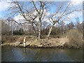
Manchester Ship Canal beacon 368
On the north bank.
Image: © Christine Johnstone
Taken: 13 Apr 2013
0.15 miles
7
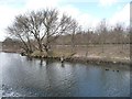
Manchester Ship Canal beacon 366
On the north bank, alongside the A57.
Image: © Christine Johnstone
Taken: 13 Apr 2013
0.16 miles
8

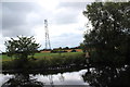
Manchester Ship Canal infrastructure
On the north bank, about a kilometre above Irlam Locks. Not sure what it is.
Image: © Christine Johnstone
Taken: 13 Apr 2013
0.16 miles
9
Manchester Ship Canal
Navigational beacon number 367 and pylon.
Image: © Alan Heardman
Taken: 13 Jul 2014
0.25 miles