IMAGES TAKEN NEAR TO
Wentworth Avenue, MANCHESTER, M44 6LQ
Introduction
This page details the photographs taken nearby to Wentworth Avenue, M44 6LQ by members of the Geograph project.
The Geograph project started in 2005 with the aim of publishing, organising and preserving representative images for every square kilometre of Great Britain, Ireland and the Isle of Man.

There are currently over 7.5m images from over14,400 individuals and you can help contribute to the project by visiting https://www.geograph.org.uk
Image Map
Images are licensed for reuse under creativecommons.org/licenses/by-sa/2.0
Notes
- Clicking on the map will re-center to the selected point.
- The higher the marker number, the further away the image location is from the centre of the postcode.
Image Listing (14 Images Found)
Images are licensed for reuse under creativecommons.org/licenses/by-sa/2.0
Image
Details
Distance
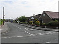
1
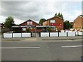
Higher Irlam Social Club
On Cutnook Lane
Image: © Kevin Waterhouse
Taken: 20 Aug 2024
0.10 miles
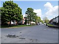
6
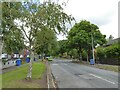
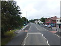
Leafy Cutnook Lane
Heading towards the M62 motorway that forms a boundary to the housing estate
Image: © Kevin Waterhouse
Taken: 20 Aug 2024
0.22 miles
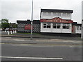
8
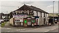
Irlam
Building in Irlam with "Turog, Best Brown Bread" sign.
Image: © Peter McDermott
Taken: 14 Jun 2017
0.22 miles
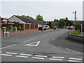
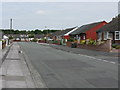
9
Shops and Medical Centre on Liverpool Road,Irlam
Image: © Raymond Knapman
Taken: 5 Aug 2014
0.22 miles