IMAGES TAKEN NEAR TO
Liverpool Road, MANCHESTER, M44 6FE
Introduction
This page details the photographs taken nearby to Liverpool Road, M44 6FE by members of the Geograph project.
The Geograph project started in 2005 with the aim of publishing, organising and preserving representative images for every square kilometre of Great Britain, Ireland and the Isle of Man.

There are currently over 7.5m images from over14,400 individuals and you can help contribute to the project by visiting https://www.geograph.org.uk
Image Map
Images are licensed for reuse under creativecommons.org/licenses/by-sa/2.0
Notes
- Clicking on the map will re-center to the selected point.
- The higher the marker number, the further away the image location is from the centre of the postcode.
Image Listing (18 Images Found)
Images are licensed for reuse under creativecommons.org/licenses/by-sa/2.0
Image
Details
Distance
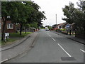
1
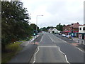
Shops and Medical Centre on Liverpool Road,Irlam
Image: © Raymond Knapman
Taken: 5 Aug 2014
0.04 miles
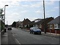
2
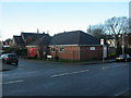
Irlam Community Centre
Small building at junction Ferryhill Road & Locklands Lane. I'm sure lots of activities take place here, but Salford doesn't seem to publicise them very effectively: http://services.salford.gov.uk/servicedirectory/service.aspx?ServiceID=1352
Image: © Mike Faherty
Taken: 23 Jan 2009
0.05 miles
3
Irlam, milestone
Milestone on Liverpool Road, once A57, now B5320, in front of St Paul's Methodist Church. Legend reads: IRLAM//9/MILES/TO/WARRINGTON//9/MILES/TO/MANCHESTER. Erected by Lancashire County Council, late C19 or early C20.
Image: © Mike Faherty
Taken: 23 Jan 2009
0.06 miles
4
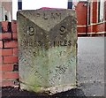
Old Milestone by the B5320, Liverpool Road, Irlam
Carved stone post by the B5320 (was A57), in parish of Irlam (Salford District), Liverpool Road, in front St Paul's Methodist Church, against wall, on South-East side of road. Lancs CC stone triangle, erected by the County Council in the 19th century.
Inscription reads:- : 9 / MILES / TO / WARRINGTON : : IRLAM : : 9 / MILES / TO / MANCHESTER :
Carved benchmark and pivot above left bevel.
Milestone Society National ID: LA_WAMA09.
Image: © Milestone Society
Taken: 27 Nov 2017
0.07 miles
5
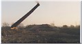
Demolition of CWS Margarine Works chimney
Picture taken from Liverpool Road Irlam of the demolition of the CWS Margarine Works Chimney.
Image: © George Poole
Taken: Unknown
0.09 miles
8
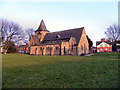
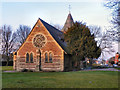
The Parish Church of St John the Baptist. Irlam
St John's is a Church of England Parish Church on Liverpool Road, in Irlam. It was consecrated on 11 July 1866 when Irlam village was mainly a farming community. This is reflected in the plain design of the church building which looks like a typical “country” church.
http://www.stjohnsirlam.org/history.htm - Church web site
Image: © David Dixon
Taken: 8 Mar 2011
0.15 miles
9
The Parish Church of St John the Baptist. Irlam
St John's is a Church of England Parish Church on Liverpool Road, in Irlam. It was consecrated on 11 July 1866 when Irlam village was mainly a farming community. This is reflected in the plain design of the church building which looks like a typical “country” church.
http://www.stjohnsirlam.org/history.htm - Church web site
Image: © David Dixon
Taken: 8 Mar 2011
0.15 miles
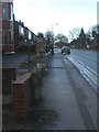
10
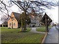
St John's Parish Church, Irlam
The Parish Church of St John on Liverpool Road, in Irlam. It was consecrated on 11 July 1866 when Irlam village was mainly a farming community. This is reflected in the plain design of the church building which looks like a typical “country” church.
This view along Liverpool Road, from near to the corner of Vicarage Road, also shows the lych gate and War Memorial.
http://www.stjohnsirlam.org/history.htm - Church web site
Image: © David Dixon
Taken: 8 Mar 2011
0.15 miles