IMAGES TAKEN NEAR TO
Berkshire Drive, MANCHESTER, M44 5YA
Introduction
This page details the photographs taken nearby to Berkshire Drive, M44 5YA by members of the Geograph project.
The Geograph project started in 2005 with the aim of publishing, organising and preserving representative images for every square kilometre of Great Britain, Ireland and the Isle of Man.

There are currently over 7.5m images from over14,400 individuals and you can help contribute to the project by visiting https://www.geograph.org.uk
Image Map
Images are licensed for reuse under creativecommons.org/licenses/by-sa/2.0
Notes
- Clicking on the map will re-center to the selected point.
- The higher the marker number, the further away the image location is from the centre of the postcode.
Image Listing (4 Images Found)
Images are licensed for reuse under creativecommons.org/licenses/by-sa/2.0
Image
Details
Distance

2
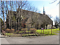
Sacred Heart Roman Catholic Church, Cadishead
The Sacred Heart RC church on Lord Street, Cadishead.
Image: © David Dixon
Taken: 18 Mar 2011
0.21 miles
3
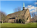
Sacred Heart Roman Catholic Church, Cadishead
The Sacred Heart RC church on Lord Street, Cadishead.
Image: © David Dixon
Taken: 18 Mar 2011
0.22 miles
4
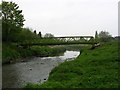
Footbridge over Glaze Brook
This bridge connects Cadishead, in Salford, with Glazebrook, Warrington. Taken from SJ 701 922
Image: © Keith Williamson
Taken: 26 Apr 2005
0.23 miles