IMAGES TAKEN NEAR TO
Dudley Road, MANCHESTER, M44 5UA
Introduction
This page details the photographs taken nearby to Dudley Road, M44 5UA by members of the Geograph project.
The Geograph project started in 2005 with the aim of publishing, organising and preserving representative images for every square kilometre of Great Britain, Ireland and the Isle of Man.

There are currently over 7.5m images from over14,400 individuals and you can help contribute to the project by visiting https://www.geograph.org.uk
Image Map
Images are licensed for reuse under creativecommons.org/licenses/by-sa/2.0
Notes
- Clicking on the map will re-center to the selected point.
- The higher the marker number, the further away the image location is from the centre of the postcode.
Image Listing (16 Images Found)
Images are licensed for reuse under creativecommons.org/licenses/by-sa/2.0
Image
Details
Distance
1
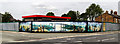
Cadishead
Mural on site at the junction of Dudley Road and Liverpool Road in Cadishead.
Image: © Peter McDermott
Taken: 14 Jun 2017
0.05 miles
2
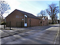
Cadishead Wesley Methodist Church
The Wesley Methodist church on Lord Street, Cadishead.
Image: © David Dixon
Taken: 18 Mar 2011
0.09 miles
3
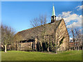
Sacred Heart Roman Catholic Church, Cadishead
The Sacred Heart RC church on Lord Street, Cadishead.
Image: © David Dixon
Taken: 18 Mar 2011
0.11 miles
4
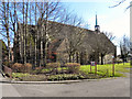
Sacred Heart Roman Catholic Church, Cadishead
The Sacred Heart RC church on Lord Street, Cadishead.
Image: © David Dixon
Taken: 18 Mar 2011
0.12 miles
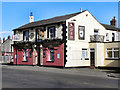
5
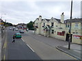
The Lion, Cadishead
The Lion public house on Liverpool Road, Cadishead.
Image: © David Dixon
Taken: 18 Mar 2011
0.14 miles
6
The Lion, Cadishead
The Lion public house on Liverpool Road, Cadishead.
Image: © David Dixon
Taken: 18 Mar 2011
0.14 miles
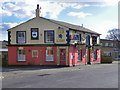
8
Coach & Horses, Cadishead
The Coach and Horses public house on Liverpool Road, Cadishead.
Image: © David Dixon
Taken: 18 Mar 2011
0.15 miles
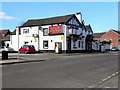
9
The Coach and Horses on Liverpool Road at Cadishead
Image: © Raymond Knapman
Taken: 5 Aug 2014
0.16 miles
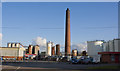
10
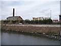
Industry at Cadishead
Mapped as a tar distillery. On the north bank of the Manchester Ship Canal, alongside the A57.
Image: © Christine Johnstone
Taken: 13 Apr 2013
0.19 miles