IMAGES TAKEN NEAR TO
Medlock Place, MANCHESTER, M43 7ZB
Introduction
This page details the photographs taken nearby to Medlock Place, M43 7ZB by members of the Geograph project.
The Geograph project started in 2005 with the aim of publishing, organising and preserving representative images for every square kilometre of Great Britain, Ireland and the Isle of Man.

There are currently over 7.5m images from over14,400 individuals and you can help contribute to the project by visiting https://www.geograph.org.uk
Image Map
Images are licensed for reuse under creativecommons.org/licenses/by-sa/2.0
Notes
- Clicking on the map will re-center to the selected point.
- The higher the marker number, the further away the image location is from the centre of the postcode.
Image Listing (188 Images Found)
Images are licensed for reuse under creativecommons.org/licenses/by-sa/2.0
Image
Details
Distance
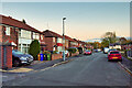
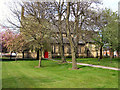
2
Droylsden Methodist Church
The fairly austere appearance in 2013 has since been improved and the garden has become established. Meanwhile the church has been engaging in numerous community support activities.
Image: © Bill Boaden
Taken: 9 Mar 2013
0.08 miles
3

Market Street, Droylsden (1961)
Cub scouts on the annual "Whit Walks", on Market Street, passing the Butchers Arms football ground (the hoardings to the left hand side of the picture). Further along (approx central, behind the walkers) is the Butchers arms pub. Just visible (on the left hand edge of the photo) above the heads of the onlookers, are the tops of two old style petrol pumps.
Image] shows a similar view (without the walkers!), taken 49 years later.
Image: © Alfred Dixon
Taken: 22 May 1961
0.08 miles
4
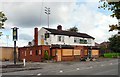
Butchers Arms
The Butchers Arms on Market Street has a history dating back to 1870 but is alas now closed.
Image
Since this photograph was taken it has been demolished Image
Image: © Gerald England
Taken: 12 Aug 2010
0.08 miles
5
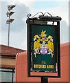
Sign of the Butchers Arms
The sign for the Butchers Arms Image In the background are the floodlights of Droylsden Football Club Ground Image
Image: © Gerald England
Taken: 12 Aug 2010
0.08 miles
6
St Mary's Church
Ashton Road, Droylsden.
Image: © David Dixon
Taken: 1 May 2010
0.08 miles
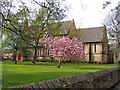
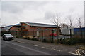
8
Droylsden Medthodist Church
Droylsden Methodist Church is a new building opened in November 2008, and is situated on Dunkirk Street. The building was funded by Tameside Council following the compulsory purchase of the old Trinity building in the town centre. The congregations of Trinity and Moorside churches transferred into the building together, and were joined later by the congregation of Abbey Hey.
Image: © John Topping
Taken: 7 Jul 2012
0.08 miles
9
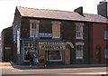
Corner shop
Baker's shop at the end of a row of terraced houses. View taken in 1979, the shop and houses have since been demolished.
Image: © David Dixon
Taken: Unknown
0.08 miles
10
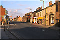
Market Street, Droylsden
Looking along Market Street, past the Greenside Lane junction in March 1979.
The Kings Head public house is just visible on the corner. In the 2010 view (Image] -albeit from the other side of the road) the Kings Head has been extended and there are now traffic lights controlling the junction.
Image: © David Dixon
Taken: Unknown
0.08 miles