IMAGES TAKEN NEAR TO
Shrewsbury Road, MANCHESTER, M43 7NJ
Introduction
This page details the photographs taken nearby to Shrewsbury Road, M43 7NJ by members of the Geograph project.
The Geograph project started in 2005 with the aim of publishing, organising and preserving representative images for every square kilometre of Great Britain, Ireland and the Isle of Man.

There are currently over 7.5m images from over14,400 individuals and you can help contribute to the project by visiting https://www.geograph.org.uk
Image Map
Images are licensed for reuse under creativecommons.org/licenses/by-sa/2.0
Notes
- Clicking on the map will re-center to the selected point.
- The higher the marker number, the further away the image location is from the centre of the postcode.
Image Listing (19 Images Found)
Images are licensed for reuse under creativecommons.org/licenses/by-sa/2.0
Image
Details
Distance
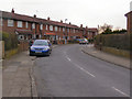
1
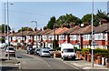
Sunnyside Road
Full of parked cars and semi-detached houses.
Image: © Gerald England
Taken: 17 Aug 2016
0.07 miles
2
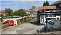
Good Fellas Salon
Hairdressers on Sunnyside Road. On the left is access to garages at the rear of Cypress Road.
Image: © Gerald England
Taken: 17 Aug 2016
0.09 miles
3
Pig On The Wall
The Pig on the Wall public house, at the corner of Springfield Road and Greenside Lane, was converted from a farm in 1978. It takes its name from an old story that once a year, some of Droylsden’s townsfolk used to watch an annual carnival by bringing a pig and sitting it on a wall to watch the passing entertainment with them.
Image: © David Dixon
Taken: 9 Apr 2010
0.17 miles
4
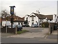
Pig On The Wall
The Pig on the Wall public house, at the corner of Springfield Road and Greenside Lane, was converted from a farm in 1978. It takes its name from an old story that once a year, some of Droylsden’s townsfolk used to watch an annual carnival by bringing a pig and sitting it on a wall to watch the passing entertainment with them.
Image: © David Dixon
Taken: 9 Apr 2010
0.17 miles
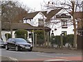
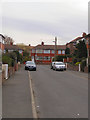
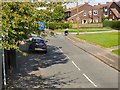
5
York Road
Part of a council estate, built in the late 1950s
Image: © David Dixon
Taken: 9 Apr 2010
0.17 miles
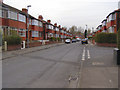
6
Sussex Drive
Looking down Sussex Drive, towards Cornwall Road.
Image: © David Dixon
Taken: 9 Apr 2010
0.17 miles

9
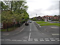
Lancaster Road, Droylsden
At the junction with Sunnyside Road.
Image: © John Topping
Taken: 22 May 2013
0.19 miles
10
Lancaster Road
Off Sunnyside Road, leading to York Road.
Image: © Gerald England
Taken: 17 Aug 2016
0.19 miles