IMAGES TAKEN NEAR TO
Brian Avenue, MANCHESTER, M43 7HN
Introduction
This page details the photographs taken nearby to Brian Avenue, M43 7HN by members of the Geograph project.
The Geograph project started in 2005 with the aim of publishing, organising and preserving representative images for every square kilometre of Great Britain, Ireland and the Isle of Man.

There are currently over 7.5m images from over14,400 individuals and you can help contribute to the project by visiting https://www.geograph.org.uk
Image Map
Images are licensed for reuse under creativecommons.org/licenses/by-sa/2.0
Notes
- Clicking on the map will re-center to the selected point.
- The higher the marker number, the further away the image location is from the centre of the postcode.
Image Listing (36 Images Found)
Images are licensed for reuse under creativecommons.org/licenses/by-sa/2.0
Image
Details
Distance
1
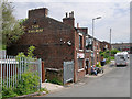
The site of the former Droylsden Station
You can see the Railway Inn on Lumb Lane, which was the main road at the time.
Image: © Bill Boaden
Taken: 20 Apr 2010
0.04 miles
2
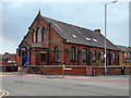
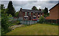
Former Moorside Methodist Church, Droylsden
Former Wesleyan Methodist chapel at the corner of Newton Street and Moorside Street. The church opened in 1884 and closed in 2008 when the congregation joined with that of Trinity Methodists, moving to Dunkirk Street (SJ 9070 9835).
Image: © David Dixon
Taken: 26 May 2018
0.05 miles
3
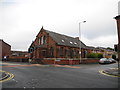
Moorside Methodist Chapel (closed) - Droylsden
At the junction of Hoppet Lane, Moorside Street and Newton Street.
Moorside Methodist closed around 2008 and the congregation transferred around this time to the new Droylsden Methodist Church situated on Dunkirk Street (SJ9098).
Image: © John Topping
Taken: 4 Oct 2012
0.07 miles
4

The Railway Inn, Littlemoss
Close to the site of the former Droylsden Station at Littlemoss.
Image: © David Dixon
Taken: 26 May 2018
0.07 miles
5
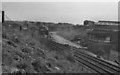
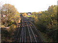
Droylsden Station Junction
The former rail junction at Droylsden Station. The path of the dismantled route to Audenshaw and Denton, branching off to the right, can still be seen clearly. The station itself had closed three years earlier, in 1968. Looking at the satellite image on Google Maps, there appears to be very little evidence of the station or junction remaining although the main Manchester-Huddersfield line is still in operation*. The footbridge, from where this picture was taken, has also gone.
*See John Topping’s photo of the junction taken in 2010 Image
Image: © David Dixon
Taken: Unknown
0.07 miles
6
The Railway Inn, Lumb Lane
Close to the site of the former Droylsden Station at Littlemoss
Image: © David Dixon
Taken: 26 May 2018
0.07 miles
8
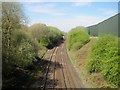
Droylsden Station Junction
Site of former junction.
Image: © John Topping
Taken: 16 Nov 2010
0.08 miles
9
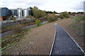
Medlock Valley Way
The huge green building on the right re-cycles wood. This was the point at which we turned back and retraced our steps to the area near Daisy Nook Garden Centre, and Daisy Nook Nature Reserve.
Image: © Tricia Neal
Taken: 16 Apr 2014
0.08 miles
10
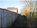
Path behind Hollybank, Droylsden
Path leading to Lumb Clough, Medlock Vale and Daisy Nook from Moorside Street and Lumb Lane.
Image: © John Topping
Taken: 18 Feb 2013
0.09 miles