IMAGES TAKEN NEAR TO
Marlborough Grove, MANCHESTER, M43 7GL
Introduction
This page details the photographs taken nearby to Marlborough Grove, M43 7GL by members of the Geograph project.
The Geograph project started in 2005 with the aim of publishing, organising and preserving representative images for every square kilometre of Great Britain, Ireland and the Isle of Man.

There are currently over 7.5m images from over14,400 individuals and you can help contribute to the project by visiting https://www.geograph.org.uk
Image Map
Images are licensed for reuse under creativecommons.org/licenses/by-sa/2.0
Notes
- Clicking on the map will re-center to the selected point.
- The higher the marker number, the further away the image location is from the centre of the postcode.
Image Listing (28 Images Found)
Images are licensed for reuse under creativecommons.org/licenses/by-sa/2.0
Image
Details
Distance
1
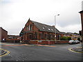
Moorside Methodist Chapel (closed) - Droylsden
At the junction of Hoppet Lane, Moorside Street and Newton Street.
Moorside Methodist closed around 2008 and the congregation transferred around this time to the new Droylsden Methodist Church situated on Dunkirk Street (SJ9098).
Image: © John Topping
Taken: 4 Oct 2012
0.07 miles
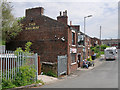
3
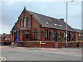
Former Moorside Methodist Church, Droylsden
Former Wesleyan Methodist chapel at the corner of Newton Street and Moorside Street. The church opened in 1884 and closed in 2008 when the congregation joined with that of Trinity Methodists, moving to Dunkirk Street (SJ 9070 9835).
Image: © David Dixon
Taken: 26 May 2018
0.08 miles
4
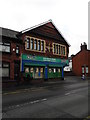
Corner of Moorside Street with Holyoake Street - Droylsden
Droylsden Industrial Co-Operative Society Limited, No 6 branch erected 1891, now a Big Saver Store.
Image: © John Topping
Taken: 4 Oct 2012
0.08 miles
6
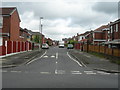
Keep Clear, Littlemoss Road - Droylsden
At the junction of Moorside Street, Littlemoss Road and Sandy Lane on the right.
Image: © John Topping
Taken: 4 Oct 2012
0.10 miles
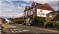
7
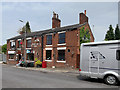
The Railway Inn, Littlemoss
Close to the site of the former Droylsden Station at Littlemoss.
Image: © David Dixon
Taken: 26 May 2018
0.11 miles
9
The Railway Inn, Lumb Lane
Close to the site of the former Droylsden Station at Littlemoss
Image: © David Dixon
Taken: 26 May 2018
0.12 miles
10

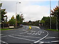
Warne Avenue Pedestrian Area
Looking southeast towards Audenshaw Junction on the former railway route from Droylsden Station Junction, which closed around 1970.
Image: © John Topping
Taken: 7 Jul 2012
0.13 miles