IMAGES TAKEN NEAR TO
Martingale Way, MANCHESTER, M43 7ES
Introduction
This page details the photographs taken nearby to Martingale Way, M43 7ES by members of the Geograph project.
The Geograph project started in 2005 with the aim of publishing, organising and preserving representative images for every square kilometre of Great Britain, Ireland and the Isle of Man.

There are currently over 7.5m images from over14,400 individuals and you can help contribute to the project by visiting https://www.geograph.org.uk
Image Map
Images are licensed for reuse under creativecommons.org/licenses/by-sa/2.0
Notes
- Clicking on the map will re-center to the selected point.
- The higher the marker number, the further away the image location is from the centre of the postcode.
Image Listing (14 Images Found)
Images are licensed for reuse under creativecommons.org/licenses/by-sa/2.0
Image
Details
Distance
1
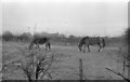
Littlemoss
Farmland, off Lumb Lane at Littlemoss.
Image: © David Dixon
Taken: Unknown
0.05 miles
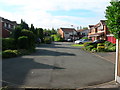
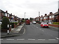
4
Pedestrian Way
Connecting Benny Lane with The Stables. Droylsden Stables Estate.
Image: © John Topping
Taken: 5 Aug 2012
0.11 miles
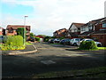
5
Rayner Lane to Sandy Lane footpath (2)
About to enter Sandy Lane, the footpath coming in on the right is from the Stables Estate.
Image: © John Topping
Taken: 13 Sep 2012
0.11 miles
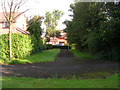
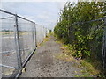
7
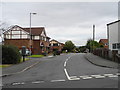
Benny Lane, Droylsden
Access road to the Stables Estate from Sandy Lane.
Image: © John Topping
Taken: 13 Sep 2012
0.12 miles
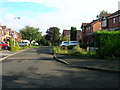
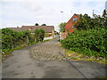
8
Saddle Grove
At the end of Banny Lane, stables estate Droylsden.
Image: © John Topping
Taken: 5 Aug 2012
0.13 miles
9
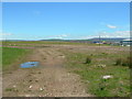
Ashton Moss
Golf Course and Driving Range development on hold, believed to be due to the economic climate.
Image: © John Topping
Taken: 30 Apr 2012
0.20 miles
10
Rayner Lane to Sandy Lane footpath (1)
Image: © John Topping
Taken: 13 Sep 2012
0.21 miles