IMAGES TAKEN NEAR TO
Manchester Road, MANCHESTER, M43 6TQ
Introduction
This page details the photographs taken nearby to Manchester Road, M43 6TQ by members of the Geograph project.
The Geograph project started in 2005 with the aim of publishing, organising and preserving representative images for every square kilometre of Great Britain, Ireland and the Isle of Man.

There are currently over 7.5m images from over14,400 individuals and you can help contribute to the project by visiting https://www.geograph.org.uk
Image Map
Images are licensed for reuse under creativecommons.org/licenses/by-sa/2.0
Notes
- Clicking on the map will re-center to the selected point.
- The higher the marker number, the further away the image location is from the centre of the postcode.
Image Listing (284 Images Found)
Images are licensed for reuse under creativecommons.org/licenses/by-sa/2.0
Image
Details
Distance
1
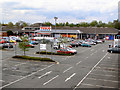
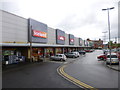
Tesco
Site of the former W.M. Christy and Sons Ltd, Fairfield Mills, Manchester Road, Droylsden.
In 1851, the first machine woven towel in the world, the Terry towel, was produced at Droylsden on an adapted loom. The Royal Turkish towels became famous and Christy's were the biggest producers in the world. Queen Victoria had a regular order.
Sadly, the mill closed at the end of the 1980's, and in 1997 Tesco opened this supermarket on the site.
Image: © David Dixon
Taken: 1 May 2010
0.01 miles
4

Droylsden Shops
Shops in the centre of Droylsden.
Image: © Gerald England
Taken: 1 Oct 2011
0.07 miles
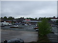
6
Droylsden Shopping Centre
Off Greenside Lane; premises seen here: Iceland, Wilko, Quality Save, Peacocks, Poundland.
Image: © Mike Faherty
Taken: 25 May 2014
0.07 miles
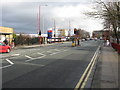
7
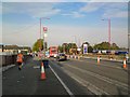
Manchester Road, Droylsden
Looking towards Manchester from outside the library opposite Tesco's. Tramlines have now been laid along the carriageways as construction of the Metrolink extension continues. There is a temporary bus stop in place. Crossing the road involves negotiating both traffic and tramlines.
Image: © Gerald England
Taken: 1 Oct 2011
0.09 miles
8
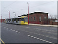
Metrolink Tram passing Droylsden Library
Metrolink Bombardier M5000 tram number 3024 passes Droylsden Library on its journey to Manchester. Although the line from Piccadilly to Droylsden wasn't officially opened until 11th February, this tram was operating as part of a free service as a "thank-you" to residents living next to the route (http://www.manchesterconfidential.co.uk/News/Droylsden-Metrolink-Route-Opening-Imminent Manchester Confidential).
The new Droylsden Tram stop on Ashton Road will operate as the temporary terminus for the Metrolink East Manchester Line Extension which will eventually run to Ashton-Under-Lyne.
http://www.lrta.org/Manchester/ashton.html LRT Association "Metrolink - Manchester to Droylsden and Ashton-Under-Lyne"
http://www.metrolink.co.uk/futuremetrolink/Pages/east-manchester-line.aspx Transport for Greater Manchester - Metrolink East Manchester Line
Image: © David Dixon
Taken: 9 Feb 2013
0.09 miles
9

Droylsden Library
On Manchester Road.
Image: © Gerald England
Taken: 6 May 2009
0.09 miles
10
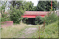
Manchester Road canal bridge
Looking from the marina. This was the line of the Hollinwood Branch http://en.wikipedia.org/wiki/Hollinwood_Branch_Canal of the Ashton Canal, which connected with the collieries to the south of Oldham. See also http://www.geograph.org.uk/photo/3591877 .
Image: © Alan Murray-Rust
Taken: 7 Aug 2013
0.10 miles