IMAGES TAKEN NEAR TO
Tideswell Road, MANCHESTER, M43 6LE
Introduction
This page details the photographs taken nearby to Tideswell Road, M43 6LE by members of the Geograph project.
The Geograph project started in 2005 with the aim of publishing, organising and preserving representative images for every square kilometre of Great Britain, Ireland and the Isle of Man.

There are currently over 7.5m images from over14,400 individuals and you can help contribute to the project by visiting https://www.geograph.org.uk
Image Map
Images are licensed for reuse under creativecommons.org/licenses/by-sa/2.0
Notes
- Clicking on the map will re-center to the selected point.
- The higher the marker number, the further away the image location is from the centre of the postcode.
Image Listing (14 Images Found)
Images are licensed for reuse under creativecommons.org/licenses/by-sa/2.0
Image
Details
Distance
1
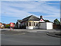
Haddon Hall, Droylsden (1)
Situated at the corner of Lewis Road and Haddon Hall Road.
Image: © John Topping
Taken: 9 Oct 2012
0.10 miles
2
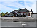
Haddon Hall, Droylsden (2)
A pub that's still open in Droylsden!
Image: © John Topping
Taken: 9 Oct 2012
0.10 miles
4
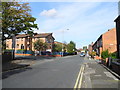
Edge Lane, Droylsden
Looking north along Edge Lane to the junction with North Road.
Image: © John Topping
Taken: 9 Oct 2012
0.21 miles
5
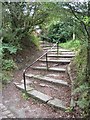
Steps on the Way
The Medlock Valley Way leaves the Clayton Vale area via these steps on its way eastwards. SJ89159938.
Image: © Keith Williamson
Taken: 21 Sep 2005
0.22 miles
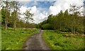
6
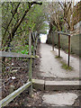
Path from Edge Lane to Clockhouse Estate
Image: © David Dixon
Taken: 9 Apr 2010
0.22 miles
7
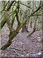
Medlock Vale
From the path between Clockhouse and Edge Lane
Image: © David Dixon
Taken: 9 Apr 2010
0.22 miles
8
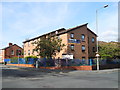
Trenchard Court Flats, Droylsden
Retirement flats at the corner of North Road and Edge Lane.
Image: © John Topping
Taken: 9 Oct 2012
0.22 miles
9
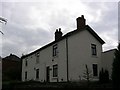
Clockhouse Farm
Clockhouse Farm, Droylsden. Plaque on wall between the centre and left upper windows gives name and date (1689!). SJ89269939.
Image: © Keith Williamson
Taken: 21 Sep 2005
0.23 miles
10
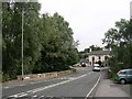
Edge Lane and Clayton Mill Bridge
The River Medlock passes under Edge Lane here. The Bay Horse Public House is visible beyond the van. SJ89089941.
Image: © Keith Williamson
Taken: 21 Sep 2005
0.24 miles