IMAGES TAKEN NEAR TO
Buxton Lane, MANCHESTER, M43 6HQ
Introduction
This page details the photographs taken nearby to Buxton Lane, M43 6HQ by members of the Geograph project.
The Geograph project started in 2005 with the aim of publishing, organising and preserving representative images for every square kilometre of Great Britain, Ireland and the Isle of Man.

There are currently over 7.5m images from over14,400 individuals and you can help contribute to the project by visiting https://www.geograph.org.uk
Image Map (Loading...)


Getting Data...Please wait
Leaflet Map data © OpenStreetMap
Images are licensed for reuse under creativecommons.org/licenses/by-sa/2.0
Notes
- Clicking on the map will re-center to the selected point.
- The higher the marker number, the further away the image location is from the centre of the postcode.
Image Listing (86 Images Found)
Images are licensed for reuse under creativecommons.org/licenses/by-sa/2.0
Image
Details
Distance
1
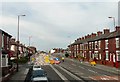
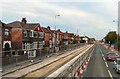
Metrolink Work Manchester Road
Viewed from the top deck of a bus. While the Metrolink tram lines are being laid two way traffic is constricted to less than half the road's width.
Image: © Gerald England
Taken: 6 Sep 2010
0.07 miles
2
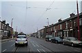
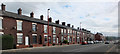
Manchester Road, Droylsden, Manchester
Image: © Steve Fareham
Taken: 17 Nov 2013
0.07 miles
3
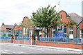
Manchester Road Primary and Nursery School
Typical local authority school from around the turn of the 20th century.
Image: © Alan Murray-Rust
Taken: 7 Aug 2013
0.08 miles
5
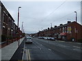
Metrolink Work on Manchester Road
Viewed from the top deck of a bus. While the Metrolink tram lines are being laid two way traffic is constricted to less than half the road's width.
Image: © Gerald England
Taken: 6 Sep 2010
0.10 miles
7

Sat behind the driver of a Manchester tram
Driver's view from a tram
Image: © Paul Foster
Taken: 23 Sep 2023
0.11 miles
8
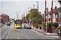
Metrolink tram near Sunnybank Road
Compared with traditional tramways which had their tracks straight down the middle of the road, modern systems are laid to suit the needs of modern road traffic, as here to allow vehicles space to wait for a right turn manoeuvre.
Image: © Alan Murray-Rust
Taken: 7 Aug 2013
0.13 miles
9
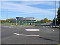
Droylsden Academy, Tameside
Viewed from the mini-roundabout, Lewis Road (left), Davenport Street (right) and Manor Road. The academy was built 2010/11 and opened in 2011 to replace Manor Road High School, which has now been demolished.
Image: © John Topping
Taken: 9 Oct 2012
0.13 miles
10
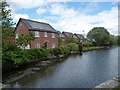
Houses on the aptly-named Waterside View
On the north bank of the Ashton Canal, immediately above Lock 16.
Image: © Christine Johnstone
Taken: 9 May 2014
0.13 miles