IMAGES TAKEN NEAR TO
Sellars Square, MANCHESTER, M43 6GT
Introduction
This page details the photographs taken nearby to Sellars Square, M43 6GT by members of the Geograph project.
The Geograph project started in 2005 with the aim of publishing, organising and preserving representative images for every square kilometre of Great Britain, Ireland and the Isle of Man.

There are currently over 7.5m images from over14,400 individuals and you can help contribute to the project by visiting https://www.geograph.org.uk
Image Map
Images are licensed for reuse under creativecommons.org/licenses/by-sa/2.0
Notes
- Clicking on the map will re-center to the selected point.
- The higher the marker number, the further away the image location is from the centre of the postcode.
Image Listing (298 Images Found)
Images are licensed for reuse under creativecommons.org/licenses/by-sa/2.0
Image
Details
Distance
1
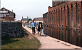
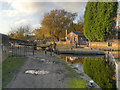
Ashton Canal at Fairfield
View from the towpath near the Fairfield Road bridge. (Compare with the modern view Image] taken from a similar viewpoint).
Image: © David Dixon
Taken: Unknown
0.02 miles
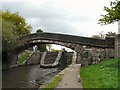
2
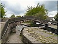
Fairfield Locks Bridge
Bridge over the Ashton Canal at Fairfield Locks.
Image: © Gerald England
Taken: 6 May 2009
0.03 miles
3
Ashton Canal: Fairfield Junction
This was the junction with the Hollinwood Branch, which is not now navigable, although I understand there are efforts to re-open part of it. This Branch lay straight on from here, whereas the main line to Dukinfield lies to the right, through the roving bridge.
Image: © Dr Neil Clifton
Taken: 30 Mar 2015
0.03 miles
4
Ashton Canal
Flats alongside the Ashton Canal near Fairfield Junction.
Image: © Peter McDermott
Taken: 30 Nov 2014
0.03 miles
5
Fairfield Locks Bridge
Bridge over the Ashton Canal at Fairfield Locks.
Image: © Gerald England
Taken: 6 May 2009
0.04 miles
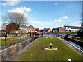
6
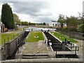
Fairfield Locks
Originally at the junction of the Ashton canal and the Hollinwood Canal, http://www.hollinwoodcanal.co.uk/canal1.htm Fairfield Locks provide access to the Droylsden Marina currently under construction. Image
Image: © Gerald England
Taken: 6 May 2009
0.04 miles
7
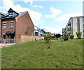
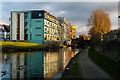
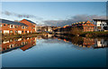
New housing at Droylsden
New housing overlooking the Ashton Canal near Droylsden Marina. A corner of undeveloped land has been taken over by weeds and Canada geese.
Image: © Gerald England
Taken: 8 Aug 2015
0.04 miles
8
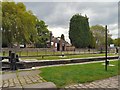
Fairfield Junction
The Ashton Canal junction with the Hollinwood Canal at Fairfield Locks.
For more about the Hollinwood Canal see http://www.penninewaterways.co.uk/ashton/hollinwood.htm
Image: © Gerald England
Taken: 6 May 2009
0.04 miles
9
Ashton Canal, Fairfield Lock
Fairfield lock is number 18, the highest, on the Ashton Canal. It is Grade II-listed (Historic England List Entry Number:1356475 http://www.heritagegateway.org.uk/Gateway/Results_Single.aspx?uid=1356475&resourceID=5 Heritage Gateway).
Image: © David Dixon
Taken: 15 Nov 2012
0.04 miles
10
Fairfield Junction
Junction on the Ashton Canal with the closed Hollinwood Branch to the left and the Ashton Canal continuing to the right.
Image: © Peter McDermott
Taken: 30 Nov 2014
0.04 miles