IMAGES TAKEN NEAR TO
Fairfield Road, MANCHESTER, M43 6AT
Introduction
This page details the photographs taken nearby to Fairfield Road, M43 6AT by members of the Geograph project.
The Geograph project started in 2005 with the aim of publishing, organising and preserving representative images for every square kilometre of Great Britain, Ireland and the Isle of Man.

There are currently over 7.5m images from over14,400 individuals and you can help contribute to the project by visiting https://www.geograph.org.uk
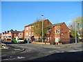
Image Map
Images are licensed for reuse under creativecommons.org/licenses/by-sa/2.0
Notes
- Clicking on the map will re-center to the selected point.
- The higher the marker number, the further away the image location is from the centre of the postcode.
Image Listing (85 Images Found)
Images are licensed for reuse under creativecommons.org/licenses/by-sa/2.0
Image
Details
Distance
1
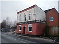
The Bowling Green pub, Fairfield Road, Droylsden
Derelict pub in the back streets of Droyslden, Tameside.
Image: © Duncan Watts
Taken: 6 Jan 2011
0.02 miles
2
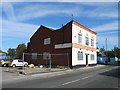
Refurbishing an ex pub, Fairfield Road - Droylsden
Formerly the Bowling Green, the property is now to let.
Image: © John Topping
Taken: 9 Oct 2012
0.04 miles
3
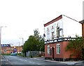
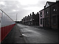
Fairfield Road
On the right hand side is the Bowling Green public house; it is still in use despite its appearance. Further down where the green car can be seen is the junction of Edge Lane and Fairfield Road. The building in the distance used to be an Electrical Engineering works but alas is no more.
Image: © Stephen Burton
Taken: 5 Oct 2005
0.06 miles
4
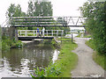
Buxton Lane Swing Bridge, Droylsden
There is a swing bridge and a footbridge across the Ashton Canal at the end of Buxton Lane, in Droylsden.
Image: © Martin Clark
Taken: Unknown
0.06 miles
5
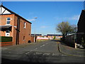
Stopford Street, Openshaw
This large area of old terraced houses is in the process of being demolished. In the past the people who lived here worked in the many large factories that used to be in the area, in more recent times quite a few of them have been occupied by immigrants from many parts of the world. On the other side of the hoarding the redevelopment is under way with the building of new town houses and apartments.
Image: © Stephen Burton
Taken: 26 Mar 2010
0.07 miles
6
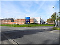
Edge Lane Business Centre, Openshaw - Manchester
At the junction of Fairfield Road and Edge Lane. The works building in the background was part of Ferguson Pailin/AEI/GEC/Alstom until closure.
Image: © John Topping
Taken: 9 Oct 2012
0.09 miles
7
Trevor Street - Higher Openshaw
View north from Toxteth Street.
Image: © John Topping
Taken: 5 Nov 2012
0.10 miles
8
Reginald Street - Higher Openshaw
Seen from Toxteth Street.
Image: © John Topping
Taken: 5 Nov 2012
0.11 miles
9
Clement Court ? Adactus Housing Association
Clement Court (sheltered housing) is situated on the corner of Toxteth Street and Cransmoor Road.
Image: © John Topping
Taken: 5 Nov 2012
0.11 miles
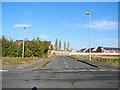
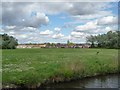
10
Football pitches on the north bank of the Ashton Canal
The distant houses are in Old Farm Crescent.
Image: © Christine Johnstone
Taken: 9 May 2014
0.11 miles