IMAGES TAKEN NEAR TO
Atkinson Road, MANCHESTER, M41 9QN
Introduction
This page details the photographs taken nearby to Atkinson Road, M41 9QN by members of the Geograph project.
The Geograph project started in 2005 with the aim of publishing, organising and preserving representative images for every square kilometre of Great Britain, Ireland and the Isle of Man.

There are currently over 7.5m images from over14,400 individuals and you can help contribute to the project by visiting https://www.geograph.org.uk
Image Map
Images are licensed for reuse under creativecommons.org/licenses/by-sa/2.0
Notes
- Clicking on the map will re-center to the selected point.
- The higher the marker number, the further away the image location is from the centre of the postcode.
Image Listing (72 Images Found)
Images are licensed for reuse under creativecommons.org/licenses/by-sa/2.0
Image
Details
Distance
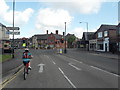
1
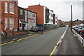
Atkinson Road
A back street in Urmston town centre.
Image: © Bill Boaden
Taken: 9 May 2019
0.03 miles
2
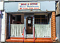
Dial A Style unisex hairdressers, Urmston, near Manchester
One of Greater Manchester's less aspirational salons.
Image: © Matt Harrop
Taken: 8 Aug 2017
0.05 miles
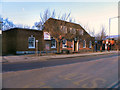
3
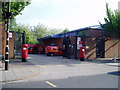
Post Office Sorting at Urmston
The Sorting office is behind the main Post Office in Urmston on Higher Road.
Image: © R Greenhalgh
Taken: 3 May 2007
0.06 miles
4
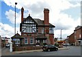
Gloucester House Medical Centre
A sign the wall says "Family Doctors since 1888". It was built for the Mayne family, and was where Dr Walter Furlong Mayne practised as a GP for the next 50 years. Also on the wall is a coat of arms Image
See the grid square discussion https://www.geograph.org.uk/discuss/index.php?action=vthread&topic=30128 for more information.
Image: © Gerald England
Taken: 26 Aug 2017
0.06 miles
5
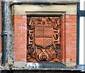
Gloucester House: Coat of arms
Coat of arms on the wall of Gloucester House Medical Centre Image which has been a family doctors since 1888.
See the grid square discussion https://www.geograph.org.uk/discuss/index.php?action=vthread&topic=30128 for more information.
Image: © Gerald England
Taken: 26 Aug 2017
0.06 miles
6
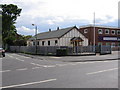
Urmston Evangelical Church
Church is on the junction of Asfield Rd. with Higher Rd. Urmston.
Image: © David Newton
Taken: 9 Jun 2009
0.08 miles
7
Urmston, fingerpost
At the junction of Station & Church Roads; a relic of pre-1964 days. In that year, the Worboys Committee recommended that all local forms of road signs be abolished; this post has a ring finial showing URMSTON UDC, which disappeared anyway 10 years later. A nice touch of local distinctiveness, even if the current local council doesn't maintain the post as it should.
Image: © Mike Faherty
Taken: 25 Jan 2009
0.08 miles
8
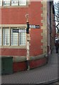
Old Direction Sign - Signpost by the B5213, Church Road, Urmston parish
Annulus finial - 2 arms; Urmston halo by the B5213, in parish of Urmston (Trafford District), Church Road junction with Station Road.
Surveyed
Milestone Society National ID: LA_SJ7694
Image: © M Faherty
Taken: 25 Jan 2009
0.08 miles
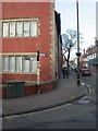
9
Junction of Stretford Road & Church Lane, Urmston
Image: © Anthony Parkes
Taken: 30 May 2010
0.08 miles
10
Urmston Post Office
The post office on higher Road, Urmston.
Image: © David Dixon
Taken: 13 Mar 2011
0.08 miles