IMAGES TAKEN NEAR TO
Queens Road, MANCHESTER, M41 9HF
Introduction
This page details the photographs taken nearby to Queens Road, M41 9HF by members of the Geograph project.
The Geograph project started in 2005 with the aim of publishing, organising and preserving representative images for every square kilometre of Great Britain, Ireland and the Isle of Man.

There are currently over 7.5m images from over14,400 individuals and you can help contribute to the project by visiting https://www.geograph.org.uk
Image Map
Images are licensed for reuse under creativecommons.org/licenses/by-sa/2.0
Notes
- Clicking on the map will re-center to the selected point.
- The higher the marker number, the further away the image location is from the centre of the postcode.
Image Listing (42 Images Found)
Images are licensed for reuse under creativecommons.org/licenses/by-sa/2.0
Image
Details
Distance
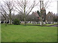
5
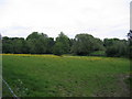
Pasture land
Looking northeast from track alongside the Cemetery
Image: © David Newton
Taken: 4 Jun 2009
0.12 miles
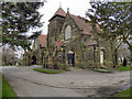
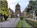
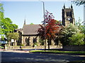
8
Urmston Cemetery Chapel
The chapel building at Urmston Cemetery
Image: © David Dixon
Taken: 2 Feb 2012
0.13 miles
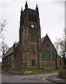
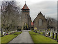
10
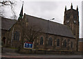
St Clement's Church, Urmston, Manchester
Image: © R Greenhalgh
Taken: 2 May 2007
0.13 miles