IMAGES TAKEN NEAR TO
Church Road, MANCHESTER, M41 9FH

Introduction

This page details the photographs taken nearby to Church Road, M41 9FH by members of the Geograph project.

The Geograph project started in 2005 with the aim of publishing, organising and preserving representative images for every square kilometre of Great Britain, Ireland and the Isle of Man.

There are currently over 7.5m images from over14,400 individuals and you can help contribute to the project by visiting https://www.geograph.org.uk

Image Map


Images are licensed for reuse under creativecommons.org/licenses/by-sa/2.0
Notes
  • Clicking on the map will re-center to the selected point.
  • The higher the marker number, the further away the image location is from the centre of the postcode.

Image Listing (56 Images Found)

Images are licensed for reuse under creativecommons.org/licenses/by-sa/2.0
  • ...
Image
Details
Distance
1
Urmston Unitarian Church
Urmston Unitarian Free Church. The junction of Queen's Rd. and Westmorland Rd.
Image: © David Newton Taken: 22 May 2009
0.11 miles
2
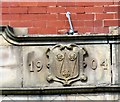
Datestone 1904
Date stone on Urmston Old Police Station Image
Image: © Gerald England Taken: 26 Aug 2017
0.13 miles
3
Urmston Old Police Station
The property was built in 1904 Image At some point it was split into two demises; 2 Church Road, The Police House and 4 Church Road, The Old Police Station. Both premises are let out as offices.
Image: © Gerald England Taken: 26 Aug 2017
0.13 miles
4
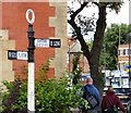
Old sign at Urmston
Fingerpost erected by Urmston Urban District Council on the corner Image of Church Road (B5213 to Flixton) and Station Road (B5214 to Barton & Eccles). A third finger pointing to Stretford (B5213) has long disappeared.
Image: © Gerald England Taken: 26 Aug 2017
0.13 miles
5
Junction of Church Road and Station Road
On the corner of Church Road (B5213 to Flixton) and Station Road (B5214 to Barton & Eccles) is an old signpost Image Behind that is Urmston Old Police Station Image built in 1904.
Image: © Gerald England Taken: 26 Aug 2017
0.13 miles
6
Signpost at Urmston
Fingerpost erected by Urmston Urban District Council outside Urmston Old Police Station Image on the corner of Church Road (B5213 to Flixton) and Station Road (B5214 to Barton & Eccles).
Image: © Gerald England Taken: 26 Aug 2017
0.13 miles
7
Urmston Unitarian Church
The church was built in 1900.
Image: © Gerald England Taken: 26 Aug 2017
0.13 miles
8
Urmston Unitarian Church
The Unitarian church, at the corner of Westmorland Road and Queen's Road, Urmston.
Image: © David Dixon Taken: 13 Mar 2011
0.14 miles
9
Old Direction Sign - Signpost by the B5213, Church Road, Urmston parish
Annulus finial - 2 arms; Urmston halo by the B5213, in parish of Urmston (Trafford District), Church Road junction with Station Road. Surveyed Milestone Society National ID: LA_SJ7694
Image: © M Faherty Taken: 25 Jan 2009
0.14 miles
10
Stretford Road meets Church Road at Urmston.
The triangle of grass with its bedding plants maintained by Trafford Council is a welcoming view to the motorist when he arrives at Urmston town centre. The brick building on the corner was originally the local police station.
Image: © R Greenhalgh Taken: 1 May 2007
0.14 miles
  • ...