IMAGES TAKEN NEAR TO
Chetwynd Avenue, MANCHESTER, M41 9BX
Introduction
This page details the photographs taken nearby to Chetwynd Avenue, M41 9BX by members of the Geograph project.
The Geograph project started in 2005 with the aim of publishing, organising and preserving representative images for every square kilometre of Great Britain, Ireland and the Isle of Man.

There are currently over 7.5m images from over14,400 individuals and you can help contribute to the project by visiting https://www.geograph.org.uk
Image Map
Images are licensed for reuse under creativecommons.org/licenses/by-sa/2.0
Notes
- Clicking on the map will re-center to the selected point.
- The higher the marker number, the further away the image location is from the centre of the postcode.
Image Listing (60 Images Found)
Images are licensed for reuse under creativecommons.org/licenses/by-sa/2.0
Image
Details
Distance
1
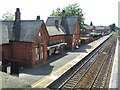
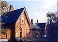
Urmston Station
This shot shows the old station buildings and platforms from Station Road Bridge over the railway line.
Image: © Dave Smethurst
Taken: 17 Jul 2005
0.10 miles
2
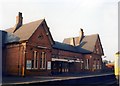
Urmston station
A classic Cheshire Lines Committee railway station, still very much in use by British Rail when photographed. However, the building's days as a railway facility were numbered, not least as its position on the Liverpool-bound side of the station was inconvenient for both staff and passengers, the latter being foremost commuters into Manchester using the opposite side of the station. For a 2009 view of the same building, see: http://www.geograph.org.uk/photo/1493469
Image: © Peter Whatley
Taken: 15 Oct 1988
0.10 miles
3
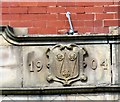
Datestone 1904
Date stone on Urmston Old Police Station Image
Image: © Gerald England
Taken: 26 Aug 2017
0.10 miles
4
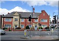
Urmston Old Police Station
The property was built in 1904 Image At some point it was split into two demises; 2 Church Road, The Police House and 4 Church Road, The Old Police Station. Both premises are let out as offices.
Image: © Gerald England
Taken: 26 Aug 2017
0.10 miles
6
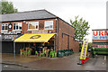
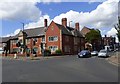
Prairie Schooner
A good outlet for real ale. However it was serving a strawberry milkshake beer, and there is something not right about that. I didn't try it.
Image: © Bill Boaden
Taken: 9 May 2019
0.11 miles
7
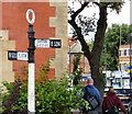
Signpost at Urmston
Fingerpost erected by Urmston Urban District Council outside Urmston Old Police Station Image on the corner of Church Road (B5213 to Flixton) and Station Road (B5214 to Barton & Eccles).
Image: © Gerald England
Taken: 26 Aug 2017
0.11 miles
8
Old sign at Urmston
Fingerpost erected by Urmston Urban District Council on the corner Image of Church Road (B5213 to Flixton) and Station Road (B5214 to Barton & Eccles). A third finger pointing to Stretford (B5213) has long disappeared.
Image: © Gerald England
Taken: 26 Aug 2017
0.11 miles
9
Junction of Church Road and Station Road
On the corner of Church Road (B5213 to Flixton) and Station Road (B5214 to Barton & Eccles) is an old signpost Image Behind that is Urmston Old Police Station Image built in 1904.
Image: © Gerald England
Taken: 26 Aug 2017
0.11 miles
10
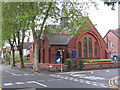
Urmston Unitarian Church
Urmston Unitarian Free Church. The junction of Queen's Rd. and Westmorland Rd.
Image: © David Newton
Taken: 22 May 2009
0.11 miles