IMAGES TAKEN NEAR TO
George Street, MANCHESTER, M41 9BA
Introduction
This page details the photographs taken nearby to George Street, M41 9BA by members of the Geograph project.
The Geograph project started in 2005 with the aim of publishing, organising and preserving representative images for every square kilometre of Great Britain, Ireland and the Isle of Man.

There are currently over 7.5m images from over14,400 individuals and you can help contribute to the project by visiting https://www.geograph.org.uk
Image Map
Images are licensed for reuse under creativecommons.org/licenses/by-sa/2.0
Notes
- Clicking on the map will re-center to the selected point.
- The higher the marker number, the further away the image location is from the centre of the postcode.
Image Listing (27 Images Found)
Images are licensed for reuse under creativecommons.org/licenses/by-sa/2.0
Image
Details
Distance
1
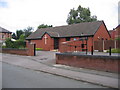
Urmston Methodist Church
The church is on George St. Urmston.
Image: © David Newton
Taken: 9 Jul 2009
0.04 miles
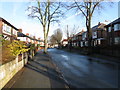
4
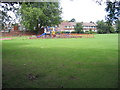
Children's Play Area
Park opposite the junction of George St. with Higher Lane, Urmston.
Image: © David Newton
Taken: 9 Jul 2009
0.07 miles
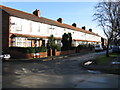
5
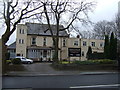
Residential home for ladies, Stretford Road, Urmston
Image: © JThomas
Taken: 9 Mar 2013
0.09 miles
6
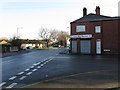
Ciss Lane Mini-Market, Urmston
Classic corner shop at the corner of two terraced rows.
Image: © Peter Whatley
Taken: 21 Jan 2009
0.09 miles
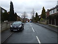
8
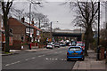
A cluttered Urmston Lane with the M60 bridge ahead
Image: © Ian Greig
Taken: 14 Feb 2012
0.11 miles
9
Kingdom Hall
Kingdom Hall of Jehovahs Witnesses, Higher Road, Urmston.
Image: © David Newton
Taken: 8 Jun 2009
0.12 miles
10
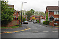
St Clements Fold
A new housing development built on the site of St Clement's Church School.
Image: © Bill Boaden
Taken: 9 May 2019
0.14 miles