IMAGES TAKEN NEAR TO
Higher Road, MANCHESTER, M41 9AB
Introduction
This page details the photographs taken nearby to Higher Road, M41 9AB by members of the Geograph project.
The Geograph project started in 2005 with the aim of publishing, organising and preserving representative images for every square kilometre of Great Britain, Ireland and the Isle of Man.

There are currently over 7.5m images from over14,400 individuals and you can help contribute to the project by visiting https://www.geograph.org.uk
Image Map
Images are licensed for reuse under creativecommons.org/licenses/by-sa/2.0
Notes
- Clicking on the map will re-center to the selected point.
- The higher the marker number, the further away the image location is from the centre of the postcode.
Image Listing (73 Images Found)
Images are licensed for reuse under creativecommons.org/licenses/by-sa/2.0
Image
Details
Distance
1
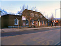
Urmston Post Office
The post office on higher Road, Urmston.
Image: © David Dixon
Taken: 13 Mar 2011
0.00 miles
2
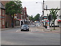
Station Road
Station Road, Urmston, looking north towards the Railway Station.
Image: © David Newton
Taken: 3 Jun 2009
0.04 miles
3
Post Office Sorting at Urmston
The Sorting office is behind the main Post Office in Urmston on Higher Road.
Image: © R Greenhalgh
Taken: 3 May 2007
0.04 miles
4
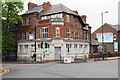
Former bank in Urmston
This was once a Williams Deacon's Bank, and it went via Williams & Glyns to become part of the Royal Bank of Scotland. RBS closed it down in August 2018. The building has not yet found an alternative use.
Image: © Bill Boaden
Taken: 9 May 2019
0.05 miles
5
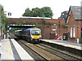
Liverpool Express At Urmston
A Manchester-Liverpool train runs non-stop through Urmston station, passing the new LED colour-light signal on the Manchester-bound platform.
Image: © Peter Whatley
Taken: 16 Sep 2009
0.05 miles
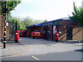
6
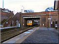
Bridge At Urmston Station
The bridge taking Station Road over the railway at the eastern end of Urmston Station.
Image: © David Dixon
Taken: 13 Mar 2011
0.05 miles
7
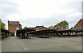
Urmston Market
The outdoor market in Urmston.
Image: © Gerald England
Taken: 18 May 2017
0.05 miles
8
Railway Road
Railway Road, Urmston, looking west towards the Railway Station. Urmston market is on the right. The railway runs in a cutting along the left of the road.
Image: © David Newton
Taken: 3 Jun 2009
0.05 miles
9
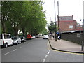
Atkinson Road
A back street in Urmston town centre.
Image: © Bill Boaden
Taken: 9 May 2019
0.06 miles
10

Croftsbank Road
Croftsbank Road, Urmston, looking south towards the station.
Image: © David Newton
Taken: 3 Jun 2009
0.06 miles