IMAGES TAKEN NEAR TO
Calderbank Avenue, MANCHESTER, M41 8SJ
Introduction
This page details the photographs taken nearby to Calderbank Avenue, M41 8SJ by members of the Geograph project.
The Geograph project started in 2005 with the aim of publishing, organising and preserving representative images for every square kilometre of Great Britain, Ireland and the Isle of Man.

There are currently over 7.5m images from over14,400 individuals and you can help contribute to the project by visiting https://www.geograph.org.uk
Image Map
Images are licensed for reuse under creativecommons.org/licenses/by-sa/2.0
Notes
- Clicking on the map will re-center to the selected point.
- The higher the marker number, the further away the image location is from the centre of the postcode.
Image Listing (9 Images Found)
Images are licensed for reuse under creativecommons.org/licenses/by-sa/2.0
Image
Details
Distance
4
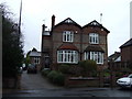
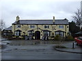
The Fox and Hounds
The Fox and Hounds, Woodsend Road, Flixton.
Image: © David Newton
Taken: 8 Jun 2009
0.21 miles
6
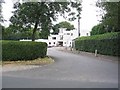
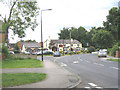
Davyhulme Park Golf Club
This is the Club House for one of the three Golf clubs in this area. It is located at SJ746954.
Image: © Dave Smethurst
Taken: 9 Aug 2005
0.22 miles
7
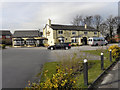
Fox and Hounds, Flixton
The Fox and Hounds public house on Woodsend Road, Flixton.
Image: © David Dixon
Taken: 14 Mar 2011
0.22 miles
8
Davyhulme Park Golf Club - Club House
Image: © Anthony Parkes
Taken: 22 Jul 2010
0.22 miles
9
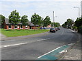
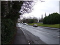
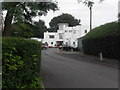
Flixton - Woodsend Road
The first building on the left hand side of the road is the local library.
Image: © Peter Whatley
Taken: 4 Jun 2009
0.24 miles