IMAGES TAKEN NEAR TO
Lowther Gardens, MANCHESTER, M41 8RJ
Introduction
This page details the photographs taken nearby to Lowther Gardens, M41 8RJ by members of the Geograph project.
The Geograph project started in 2005 with the aim of publishing, organising and preserving representative images for every square kilometre of Great Britain, Ireland and the Isle of Man.

There are currently over 7.5m images from over14,400 individuals and you can help contribute to the project by visiting https://www.geograph.org.uk
Image Map
Images are licensed for reuse under creativecommons.org/licenses/by-sa/2.0
Notes
- Clicking on the map will re-center to the selected point.
- The higher the marker number, the further away the image location is from the centre of the postcode.
Image Listing (18 Images Found)
Images are licensed for reuse under creativecommons.org/licenses/by-sa/2.0
Image
Details
Distance
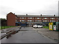
5
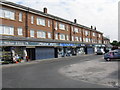
Flixton - Shopping Parade West of Woodbridge Road
Image: © Peter Whatley
Taken: 4 Jun 2009
0.17 miles
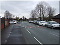
7
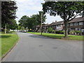
Woodsend Crescent Road
To the left is a large open space for recreation
Image: © Kevin Waterhouse
Taken: 10 May 2024
0.18 miles
8

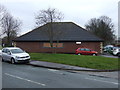
Woodsend Library
Woodsend Library, at the junction of Woodsend Road and Woodbridge Road.
Image: © David Dixon
Taken: 14 Mar 2011
0.18 miles
9

On the Manchester Ship Canal
Looking from the stern of a Mersey ferry heading south on the canal having passed under the power lines seen here.
Image: © Trevor Harris
Taken: 2 Sep 2012
0.18 miles