IMAGES TAKEN NEAR TO
Skipton Drive, MANCHESTER, M41 8PD
Introduction
This page details the photographs taken nearby to Skipton Drive, M41 8PD by members of the Geograph project.
The Geograph project started in 2005 with the aim of publishing, organising and preserving representative images for every square kilometre of Great Britain, Ireland and the Isle of Man.

There are currently over 7.5m images from over14,400 individuals and you can help contribute to the project by visiting https://www.geograph.org.uk
Image Map
Images are licensed for reuse under creativecommons.org/licenses/by-sa/2.0
Notes
- Clicking on the map will re-center to the selected point.
- The higher the marker number, the further away the image location is from the centre of the postcode.
Image Listing (49 Images Found)
Images are licensed for reuse under creativecommons.org/licenses/by-sa/2.0
Image
Details
Distance
1
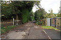
The top of Bent Lanes
This is as far as you can get without going onto private land. There is no access to the Ship Canal.
Image: © Bill Boaden
Taken: 9 Oct 2019
0.03 miles
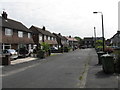
2
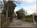
Bent Lanes
Gate at the end of Bent Lanes.
Image: © David Dixon
Taken: 14 Mar 2011
0.04 miles
8
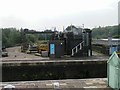
Sluices, Barton Locks, Manchester Ship Canal
Image: © Michael Steele
Taken: 17 Sep 2008
0.16 miles
10
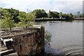
Manchester Ship Canal
Looking across Barton Locks from the mersey ferry.
Image: © Alan Heardman
Taken: 13 Jul 2014
0.16 miles