IMAGES TAKEN NEAR TO
Dalveen Avenue, MANCHESTER, M41 7DP
Introduction
This page details the photographs taken nearby to Dalveen Avenue, M41 7DP by members of the Geograph project.
The Geograph project started in 2005 with the aim of publishing, organising and preserving representative images for every square kilometre of Great Britain, Ireland and the Isle of Man.

There are currently over 7.5m images from over14,400 individuals and you can help contribute to the project by visiting https://www.geograph.org.uk
Image Map
Images are licensed for reuse under creativecommons.org/licenses/by-sa/2.0
Notes
- Clicking on the map will re-center to the selected point.
- The higher the marker number, the further away the image location is from the centre of the postcode.
Image Listing (25 Images Found)
Images are licensed for reuse under creativecommons.org/licenses/by-sa/2.0
Image
Details
Distance
3
Cenotaph
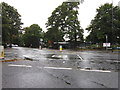
This is the Cenotaph located at the Nags Head Roundabout in Davyhulme. The Roundabout is named after the Pub which is behind me when I took this picture.
Image: © Dave Smethurst
Taken: 13 Jul 2005
0.17 miles
4
Cornerstone Methodist Church
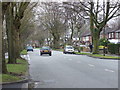
The Cornerstone Methodist Church, on Hayeswater Road.
Image: © David Dixon
Taken: 13 Mar 2011
0.19 miles
6
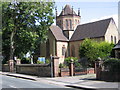
St Mary the Virgin
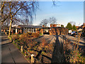
The Church of St. Mary the Virgin, Davyhulme Rd.
Image: © David Newton
Taken: 30 Jul 2009
0.20 miles
8
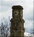
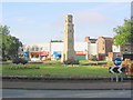
War Memorial Clock
The Grade II listed https://historicengland.org.uk/listing/the-list/list-entry/1416963 war memorial at Davyhulme Circle Image The uppermost part of the cenotaph on all four faces has an illuminated brass clock dial glazed in opal. Below the clock dials is a carved band with relief lettering that reads in an anti-clockwise direction around the cenotaph from the west face: 'IN MEMORY OF/ THOSE WHO FELL IN/ THE GREAT WAR/ 1914 - 1918'. The east face of the cenotaph has a small timber hatch set to the centre of the shaft that provides access to the clock mechanism inside, which consists of a Graham deadbeat escapement and a nickel steel pendulum.
Image: © Gerald England
Taken: 28 Apr 2018
0.21 miles
10
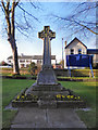
St Mary's Davyhulme, Great War Memorial
Along with most parishes in the country, St Mary’s suffered significant losses during the 1914 - 1918 Great War. This granite celtic cross was erected outside the church, in 1922, as a war memorial, and the garden of remembrance was landscaped and dedicated in 1960. The memorial was cleaned and renovated in 2008, in time for the 90th anniversary of armistice day on 11th November 2008.
The names of twenty one men from St. Mary’s who died are inscribed on the front of the war memorial (Image] ).
The other inscriptions on this memorial are :
Front:
In honoured memory of the men from the church and schools of this parish who gave their lives in the Great War 1914 - 1918
Left hand side:
Remember before God the gallant souls whose names are written here
Right hand side:
Their memory will never die
http://www.stmarysdavyhulme.org/our-church/war-memorials/
Image: © David Dixon
Taken: 13 Mar 2011
0.21 miles