IMAGES TAKEN NEAR TO
Uplands Road, MANCHESTER, M41 6PU
Introduction
This page details the photographs taken nearby to Uplands Road, M41 6PU by members of the Geograph project.
The Geograph project started in 2005 with the aim of publishing, organising and preserving representative images for every square kilometre of Great Britain, Ireland and the Isle of Man.

There are currently over 7.5m images from over14,400 individuals and you can help contribute to the project by visiting https://www.geograph.org.uk
Image Map
Images are licensed for reuse under creativecommons.org/licenses/by-sa/2.0
Notes
- Clicking on the map will re-center to the selected point.
- The higher the marker number, the further away the image location is from the centre of the postcode.
Image Listing (37 Images Found)
Images are licensed for reuse under creativecommons.org/licenses/by-sa/2.0
Image
Details
Distance
1

Path behind the houses
Part of the several areas of green space close to the edge of Flixton.
Image: © Bill Boaden
Taken: 22 May 2017
0.06 miles
2
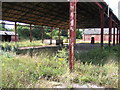
The Old Brickworks
The derelict Brickworks, Four Lane Ends, Flixton. All that remains in this abandoned shell of a building is the weighbridge mechanism at the far end, used to calculate the loads of the lorries carrying the raw material from the local claypits.
Image: © David Newton
Taken: 30 Jul 2009
0.07 miles
3
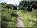
Look right look left and look right again
In the days when the local Brickworks was in full production lorries, whose drivers were paid per load, used to thunder up and down this road at life threatening speed delivering clay from the local claypits. Nature has now reclaimed it and made it into a pleasant rural pathway.
Image: © David Newton
Taken: 30 Jul 2009
0.07 miles
4

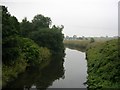
The River Mersey
Looking downstream from Flixton Bridge. Ugly pipes like this one are a common feature along the Mersey.
Image: © Bill Boaden
Taken: 22 May 2017
0.08 miles
5

Flixton Brick Works
Flixton Brick Works at Four Lane Ends.
Image: © Peter McDermott
Taken: 21 Feb 2021
0.08 miles
7
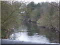
River Mersey from Flixton Bridge
Looking upstream from Flixton Bridge. The river has meandered across Urmston Meadows and will join the Manchester Ship Canal in a short distance (in Image).
Image: © Keith Williamson
Taken: 6 Sep 2005
0.08 miles
8

River Mersey from Flixton Bridge
Looking downstream from the bridge at Flixton. SJ74239377.
Image: © Keith Williamson
Taken: 6 Sep 2005
0.08 miles
9
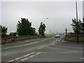
Flixton Bridge
The bridge carries the B5158, Flixton Road (also known locally as "the Mile Road") over the River Mersey. SJ74239377
Image: © Keith Williamson
Taken: 6 Sep 2005
0.08 miles
10
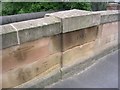
Benchmark
Detail of date inscription and OS benchmark on Flixton Bridge. SJ74239377
Image: © Keith Williamson
Taken: 6 Sep 2005
0.08 miles