IMAGES TAKEN NEAR TO
Flixton Road, MANCHESTER, M41 6JE
Introduction
This page details the photographs taken nearby to Flixton Road, M41 6JE by members of the Geograph project.
The Geograph project started in 2005 with the aim of publishing, organising and preserving representative images for every square kilometre of Great Britain, Ireland and the Isle of Man.

There are currently over 7.5m images from over14,400 individuals and you can help contribute to the project by visiting https://www.geograph.org.uk
Image Map
Images are licensed for reuse under creativecommons.org/licenses/by-sa/2.0
Notes
- Clicking on the map will re-center to the selected point.
- The higher the marker number, the further away the image location is from the centre of the postcode.
Image Listing (16 Images Found)
Images are licensed for reuse under creativecommons.org/licenses/by-sa/2.0
Image
Details
Distance
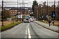
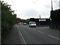
3
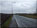
The Mile Road
The Mile Road (Flixton Rd.) at its junction with Manchester Rd., Carrington Lane and Isherwood Rd. Although known locally as the Mile Rd. its only about half a mile long.
Image: © David Newton
Taken: 23 Jun 2009
0.10 miles
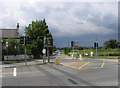
4
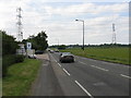
Manchester Road (A6144), Carrington
Heading east.
Image: © JThomas
Taken: 9 Mar 2013
0.10 miles
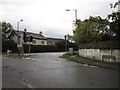
10
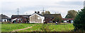
Dainewell Farm
Buildings at Dainewell Farm.
Image: © Peter McDermott
Taken: 11 Oct 2014
0.17 miles