IMAGES TAKEN NEAR TO
Church Road, MANCHESTER, M41 6HJ
Introduction
This page details the photographs taken nearby to Church Road, M41 6HJ by members of the Geograph project.
The Geograph project started in 2005 with the aim of publishing, organising and preserving representative images for every square kilometre of Great Britain, Ireland and the Isle of Man.

There are currently over 7.5m images from over14,400 individuals and you can help contribute to the project by visiting https://www.geograph.org.uk
Image Map
Images are licensed for reuse under creativecommons.org/licenses/by-sa/2.0
Notes
- Clicking on the map will re-center to the selected point.
- The higher the marker number, the further away the image location is from the centre of the postcode.
Image Listing (14 Images Found)
Images are licensed for reuse under creativecommons.org/licenses/by-sa/2.0
Image
Details
Distance
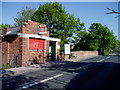
4
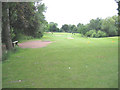
The 10th. Fairway
The first of the William Wroe Golf Course's second nine holes, which are south of the railway line.
Image: © David Newton
Taken: 9 Jun 2009
0.19 miles

6
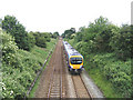
Manchester to Liverpool Railtrack
Taken from " Penny Bridge " looking towards Chassen Road Station.
Image: © David Newton
Taken: 9 Jun 2009
0.21 miles
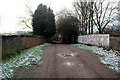
7
Track To " Penny Bridge "
Track leading over " Penny Bridge ". William Wroe Golf Course is to the left beyond the railings.
Image: © David Newton
Taken: 9 Jun 2009
0.21 miles
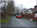
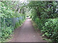
9
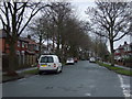
Penny Bridge Lane
Looking down the lane and bridge.
Image: © Phill
Taken: 27 Dec 2014
0.23 miles
10
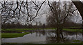
Flooding at The William Wroe Golf Course
Is there a pond under all that water?
Image: © Ian Greig
Taken: 10 Jan 2012
0.23 miles