IMAGES TAKEN NEAR TO
Snowden Avenue, MANCHESTER, M41 6FE
Introduction
This page details the photographs taken nearby to Snowden Avenue, M41 6FE by members of the Geograph project.
The Geograph project started in 2005 with the aim of publishing, organising and preserving representative images for every square kilometre of Great Britain, Ireland and the Isle of Man.

There are currently over 7.5m images from over14,400 individuals and you can help contribute to the project by visiting https://www.geograph.org.uk
Image Map
Images are licensed for reuse under creativecommons.org/licenses/by-sa/2.0
Notes
- Clicking on the map will re-center to the selected point.
- The higher the marker number, the further away the image location is from the centre of the postcode.
Image Listing (9 Images Found)
Images are licensed for reuse under creativecommons.org/licenses/by-sa/2.0
Image
Details
Distance
1
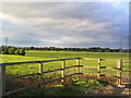
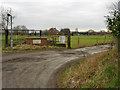
Farmland
This picture was taken looking across the pasture land of SJ7593 from SJ754929. The pasture is typical of this area once you get clear of the housing.
Image: © Dave Smethurst
Taken: 28 Aug 2005
0.06 miles
2
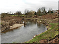
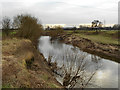
River Mersey
Looking downstream. The houses on the skyline are on Redesmere Park.
Image: © David Dixon
Taken: 2 Feb 2012
0.11 miles
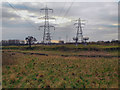
3
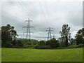
Electricity cables across the River Mersey
The pylons are on the far bank of the River Mersey
Image: © Kevin Waterhouse
Taken: 29 May 2024
0.15 miles
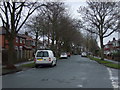
4
Path Behind Redesmere Park
The footpath behind Redesmere Park follows the line of the overhead power lines.
Image: © David Dixon
Taken: 2 Feb 2012
0.18 miles