IMAGES TAKEN NEAR TO
Handel Avenue, MANCHESTER, M41 5PG
Introduction
This page details the photographs taken nearby to Handel Avenue, M41 5PG by members of the Geograph project.
The Geograph project started in 2005 with the aim of publishing, organising and preserving representative images for every square kilometre of Great Britain, Ireland and the Isle of Man.

There are currently over 7.5m images from over14,400 individuals and you can help contribute to the project by visiting https://www.geograph.org.uk
Image Map
Images are licensed for reuse under creativecommons.org/licenses/by-sa/2.0
Notes
- Clicking on the map will re-center to the selected point.
- The higher the marker number, the further away the image location is from the centre of the postcode.
Image Listing (33 Images Found)
Images are licensed for reuse under creativecommons.org/licenses/by-sa/2.0
Image
Details
Distance
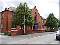
1
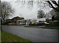
Urmston Ambulance Station
On Bowfell Road.
Image: © Mike Faherty
Taken: 17 Nov 2010
0.03 miles

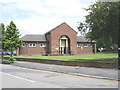
6
Davyhulme (Wesley) Methodist Church
Methodist Church, Brook Road, Flixton.
Image: © David Newton
Taken: 9 Jun 2009
0.07 miles
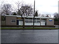
7
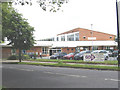
Urmston Sports Centre
Bowfell Road Library and Urmston Sports Centre, Bowfell Rd. Flixton.
Image: © David Newton
Taken: 9 Jun 2009
0.08 miles
8
Urmston Leisure Centre
On Bowfell Road; some signs refer to the building as Urmston Sports Centre. http://www.traffordleisure.co.uk/centres/urmston/
Image: © Mike Faherty
Taken: 17 Nov 2010
0.08 miles
9
The Old Library
Building on the junction of Brook Rd. and Bowfell Rd. used to be the Flixton Branch Library.
Image: © David Newton
Taken: 9 Jun 2009
0.09 miles
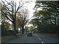
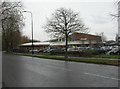
10
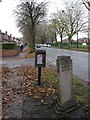
Urmston, milestone
On Bowfell Road, a concrete milestone unveiled in 1937 to commemorate the opening of this road in 1937. The other face shows distances to Lymm and Chester.
Image: © Mike Faherty
Taken: 17 Nov 2010
0.09 miles