IMAGES TAKEN NEAR TO
Winifred Road, MANCHESTER, M41 5FT
Introduction
This page details the photographs taken nearby to Winifred Road, M41 5FT by members of the Geograph project.
The Geograph project started in 2005 with the aim of publishing, organising and preserving representative images for every square kilometre of Great Britain, Ireland and the Isle of Man.

There are currently over 7.5m images from over14,400 individuals and you can help contribute to the project by visiting https://www.geograph.org.uk
Image Map
Images are licensed for reuse under creativecommons.org/licenses/by-sa/2.0
Notes
- Clicking on the map will re-center to the selected point.
- The higher the marker number, the further away the image location is from the centre of the postcode.
Image Listing (45 Images Found)
Images are licensed for reuse under creativecommons.org/licenses/by-sa/2.0
Image
Details
Distance
1
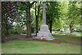
War memorial in Urmston
In a small enclave at the southern end of Golden Hill Park.
Image: © Bill Boaden
Taken: 9 May 2019
0.05 miles
2
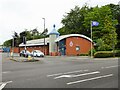
Urmston Police Station
On Croft Banks Road
Image: © Kevin Waterhouse
Taken: 29 May 2024
0.07 miles
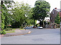
3
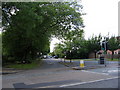
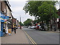
Moorside Road
Looking west down Moorside Rd. from its junction with Crofts Bank Rd.
Image: © David Newton
Taken: 11 Jun 2009
0.09 miles
4
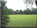
Goldenhill Park
View across Goldenhill Park, Urmston, towards the children's play area.
Image: © David Newton
Taken: 8 Jun 2009
0.09 miles
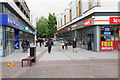
5

Pop-up stalls in Urmston
Despite the heavy rain there are still shoppers braving the weather.
Image: © Gerald England
Taken: 20 May 2017
0.11 miles
6
Golden Way
A walkway in Eden Square Shopping Centre.
Image: © Bill Boaden
Taken: 9 May 2019
0.13 miles
7
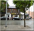
Charlie's Proper Fish & Chip Shop
A traditional chippie on the edge of the Urmston precinct.
Image: © Gerald England
Taken: 20 May 2017
0.14 miles
8
Winchester Road
Looking east down Winchester Rd. from its junction with Crofts Bank Rd.
Image: © David Newton
Taken: 11 Jun 2009
0.15 miles
9
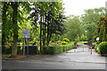
Davyhulme Park
The southern entrance off Winchester Road.
Image: © Bill Boaden
Taken: 9 May 2019
0.15 miles
10
Flixton road
Flixton road, Urmston, looking east towards Urmston Station.
Image: © David Newton
Taken: 3 Jun 2009
0.16 miles