IMAGES TAKEN NEAR TO
Kirkstall Road, MANCHESTER, M41 0GP
Introduction
This page details the photographs taken nearby to Kirkstall Road, M41 0GP by members of the Geograph project.
The Geograph project started in 2005 with the aim of publishing, organising and preserving representative images for every square kilometre of Great Britain, Ireland and the Isle of Man.

There are currently over 7.5m images from over14,400 individuals and you can help contribute to the project by visiting https://www.geograph.org.uk
Image Map
Images are licensed for reuse under creativecommons.org/licenses/by-sa/2.0
Notes
- Clicking on the map will re-center to the selected point.
- The higher the marker number, the further away the image location is from the centre of the postcode.
Image Listing (8 Images Found)
Images are licensed for reuse under creativecommons.org/licenses/by-sa/2.0
Image
Details
Distance
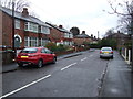
1
Winchester Road
Approaching the overbridge of the M60 motorway
Image: © Kevin Waterhouse
Taken: 29 May 2024
0.20 miles
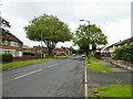
2
Railway Road
Looking westerly from its junction with Moss Vale Rd.
Image: © David Newton
Taken: 9 Jul 2009
0.21 miles
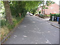
3
Railway Road
Looking easterly from the footbridge.
Image: © David Newton
Taken: 9 Jul 2009
0.21 miles
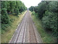
4
Railway Westbound
Looking westbound, towards footbridge, from Moss Vale Rd. bridge.
Image: © David Newton
Taken: 9 Jul 2009
0.24 miles
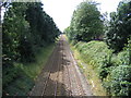
5
Railway looking eastbound
View of Manchester-Liverpool railway from the footbridge.
Image: © David Newton
Taken: 9 Jul 2009
0.24 miles
6
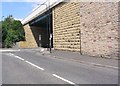
M60 Bridge for Winchester Road
This is where the M60 passes over Winchester and Moss Vale Roads at SJ775951.
Image: © Dave Smethurst
Taken: 17 Jul 2005
0.24 miles
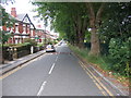
7
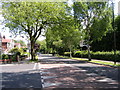
Canterbury Road
From the junction of Exeter Rd. with Canterbury Rd. Davyhulme Park is on the left with Davyhulme Infant and Junior Schools beyond.
Image: © David Newton
Taken: 11 Jun 2009
0.24 miles