IMAGES TAKEN NEAR TO
Crofts Bank Road, MANCHESTER, M41 0AA
Introduction
This page details the photographs taken nearby to Crofts Bank Road, M41 0AA by members of the Geograph project.
The Geograph project started in 2005 with the aim of publishing, organising and preserving representative images for every square kilometre of Great Britain, Ireland and the Isle of Man.

There are currently over 7.5m images from over14,400 individuals and you can help contribute to the project by visiting https://www.geograph.org.uk
Image Map
Images are licensed for reuse under creativecommons.org/licenses/by-sa/2.0
Notes
- Clicking on the map will re-center to the selected point.
- The higher the marker number, the further away the image location is from the centre of the postcode.
Image Listing (48 Images Found)
Images are licensed for reuse under creativecommons.org/licenses/by-sa/2.0
Image
Details
Distance
1
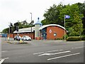
Urmston Police Station
On Croft Banks Road
Image: © Kevin Waterhouse
Taken: 29 May 2024
0.03 miles
2
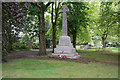
War memorial in Urmston
In a small enclave at the southern end of Golden Hill Park.
Image: © Bill Boaden
Taken: 9 May 2019
0.05 miles
3
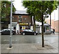
Charlie's Proper Fish & Chip Shop
A traditional chippie on the edge of the Urmston precinct.
Image: © Gerald England
Taken: 20 May 2017
0.10 miles
4
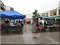
Pop-up stalls in Urmston
Despite the heavy rain there are still shoppers braving the weather.
Image: © Gerald England
Taken: 20 May 2017
0.11 miles
5
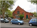
Greenfield Church, Urmston
Urmston Baptist Church on Primrose Avenue was founded in 1903. In 1976 it joined with the local Congregational Church under The Sharing of Church Buildings Act. Although legally two churches the denominations worship together and share the government of the church equally, maintaining only the minimum denominational bodies to satisfy legal requirements. There are two church rolls and those coming into membership choose which roll they will be added to, according to denominational background. http://www.greenfieldchurch.co.uk/
Image: © Gerald England
Taken: 18 May 2017
0.11 miles
6
Greenfield Church, Urmston
Urmston Baptist Church on Primrose Avenue was founded in 1903. In 1976 it joined with the local Congregational Church under The Sharing of Church Buildings Act. Although legally two churches the denominations worship together and share the government of the church equally, maintaining only the minimum denominational bodies to satisfy legal requirements. There are two church rolls and those coming into membership choose which roll they will be added to, according to denominational background. http://www.greenfieldchurch.co.uk/
Image: © Gerald England
Taken: 18 May 2017
0.12 miles
7
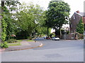
Winchester Road
Looking east down Winchester Rd. from its junction with Crofts Bank Rd.
Image: © David Newton
Taken: 11 Jun 2009
0.12 miles
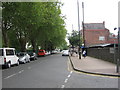
8

Croftsbank Road
Croftsbank Road, Urmston, looking south towards the station.
Image: © David Newton
Taken: 3 Jun 2009
0.12 miles
9
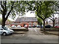
Golden Way
A walkway in Eden Square Shopping Centre.
Image: © Bill Boaden
Taken: 9 May 2019
0.13 miles
10
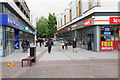
Railway Road
Railway Road, Urmston, looking west towards the Railway Station. Urmston market is on the right. The railway runs in a cutting along the left of the road.
Image: © David Newton
Taken: 3 Jun 2009
0.13 miles