IMAGES TAKEN NEAR TO
Emmett Street East, MANCHESTER, M40 8PD
Introduction
This page details the photographs taken nearby to Emmett Street East, M40 8PD by members of the Geograph project.
The Geograph project started in 2005 with the aim of publishing, organising and preserving representative images for every square kilometre of Great Britain, Ireland and the Isle of Man.

There are currently over 7.5m images from over14,400 individuals and you can help contribute to the project by visiting https://www.geograph.org.uk
Image Map
Images are licensed for reuse under creativecommons.org/licenses/by-sa/2.0
Notes
- Clicking on the map will re-center to the selected point.
- The higher the marker number, the further away the image location is from the centre of the postcode.
Image Listing (37 Images Found)
Images are licensed for reuse under creativecommons.org/licenses/by-sa/2.0
Image
Details
Distance
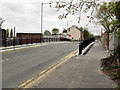
1
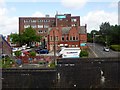
Pub and flats
City scene near Newton Heath, Manchester.
Image: © philandju
Taken: 4 Aug 2017
0.05 miles
3
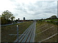
Metro line west of Monsall Road Bridge
Image: © Alexander P Kapp
Taken: 5 Oct 2011
0.08 miles
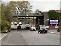
4

Railway bridge over Monsall Road, Harpurhey
Image: © Alexander P Kapp
Taken: 5 Oct 2011
0.09 miles
6
Monsall Road
The bridge over the former railway line, now being made ready for the Metrolink tramway.
Image: © David Dixon
Taken: 13 Apr 2011
0.10 miles
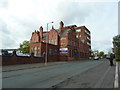
7
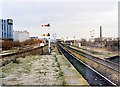
Brewery Sidings junction, Miles Platting 1989
Looking NE from Miles Platting station, the signalbox at Brewery Sidings is in the middle distance, with Wilsons brewery's 1970s buildings on the left. In 2008, nothing recognisable is left, the whole area having become part of Manchester's urban regeneration zone, the station closed and the tracks realigned and resignalled.
Image: © Peter Whatley
Taken: 14 Jan 1989
0.11 miles
8
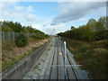
Newly laid Metro line, west of Central Park Station
Image: © Alexander P Kapp
Taken: 5 Oct 2011
0.12 miles
9
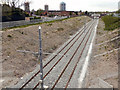
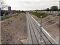
Metrolink Extension
Shown on the OS map as "dismantled railway"; new track has been laid on this old railway route, ready for the extension to the Metrolink tramway to run from Manchester to Oldham. This is looking towards Manchester, from Monsall Road. Sanderson Street is to the left of the cutting.
Image: © David Dixon
Taken: 13 Apr 2011
0.12 miles
10
Metrolink Extension
Shown on the OS map as "dismantled railway", new track has been laid on this old railway route, ready for the extension to the Metrolink tramway to run from Manchester to Oldham. This is looking towards Manchester, from Monsall Road.
Image: © David Dixon
Taken: 13 Apr 2011
0.12 miles