IMAGES TAKEN NEAR TO
Monsall Road, MANCHESTER, M40 8NQ
Introduction
This page details the photographs taken nearby to Monsall Road, M40 8NQ by members of the Geograph project.
The Geograph project started in 2005 with the aim of publishing, organising and preserving representative images for every square kilometre of Great Britain, Ireland and the Isle of Man.

There are currently over 7.5m images from over14,400 individuals and you can help contribute to the project by visiting https://www.geograph.org.uk
Image Map
Images are licensed for reuse under creativecommons.org/licenses/by-sa/2.0
Notes
- Clicking on the map will re-center to the selected point.
- The higher the marker number, the further away the image location is from the centre of the postcode.
Image Listing (5 Images Found)
Images are licensed for reuse under creativecommons.org/licenses/by-sa/2.0
Image
Details
Distance
1
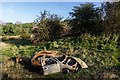
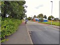
Harpurhey
Burnt out car in Harpurhey.
Image: © Peter McDermott
Taken: 3 Oct 2017
0.17 miles
2
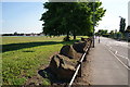
Upper Monsall Street
With defences to prevent unauthorised vehicles getting onto the grass.
Image: © Bill Boaden
Taken: 17 Jun 2010
0.18 miles
3
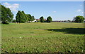
Open space in Monsall
I am pretty sure this was the former site of the Monsall Isolation Hospital.
Image: © Bill Boaden
Taken: 17 Jun 2010
0.21 miles
4
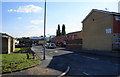
Chevington Drive, Harpurhey
In the background can be seen the new Manchester Communication Academy, built on waste land on the corner of Rochdale Road and Queens Road.
Image: © Bill Boaden
Taken: 17 Jun 2010
0.25 miles