IMAGES TAKEN NEAR TO
Clifton Street, MANCHESTER, M40 8HF
Introduction
This page details the photographs taken nearby to Clifton Street, M40 8HF by members of the Geograph project.
The Geograph project started in 2005 with the aim of publishing, organising and preserving representative images for every square kilometre of Great Britain, Ireland and the Isle of Man.

There are currently over 7.5m images from over14,400 individuals and you can help contribute to the project by visiting https://www.geograph.org.uk
Image Map
Images are licensed for reuse under creativecommons.org/licenses/by-sa/2.0
Notes
- Clicking on the map will re-center to the selected point.
- The higher the marker number, the further away the image location is from the centre of the postcode.
Image Listing (43 Images Found)
Images are licensed for reuse under creativecommons.org/licenses/by-sa/2.0
Image
Details
Distance
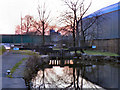
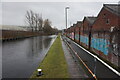
2
Railway Bridge
Rochdale Canal, just below Lock 76
Image: © Mike Todd
Taken: 13 Jun 2011
0.15 miles
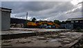
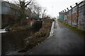
3
Railway bridge next to lock #76, Rochdale Canal
Image: © Ian S
Taken: 2 Mar 2022
0.15 miles
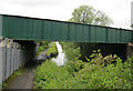
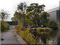
4
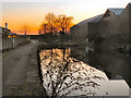
Rochdale Canal
Looking towards Miles Platting from the towpath, just to the west of Grimshaw Lane.
Image: © David Dixon
Taken: 2 Mar 2011
0.15 miles
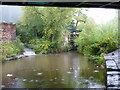
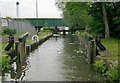
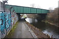
9
Rochdale Canal, Lock#76 (Slater's Lower)
Slater's Lower Lock, number 75 on the Rochdale Canal, to the west of Grimshaw Lane. The bridge carrying the Manchester Victoria to Ashton railway line can be seen in the background.
Image: © David Dixon
Taken: 29 Sep 2012
0.16 miles