IMAGES TAKEN NEAR TO
Varley Street, MANCHESTER, M40 8BW
Introduction
This page details the photographs taken nearby to Varley Street, M40 8BW by members of the Geograph project.
The Geograph project started in 2005 with the aim of publishing, organising and preserving representative images for every square kilometre of Great Britain, Ireland and the Isle of Man.

There are currently over 7.5m images from over14,400 individuals and you can help contribute to the project by visiting https://www.geograph.org.uk
Image Map
Images are licensed for reuse under creativecommons.org/licenses/by-sa/2.0
Notes
- Clicking on the map will re-center to the selected point.
- The higher the marker number, the further away the image location is from the centre of the postcode.
Image Listing (84 Images Found)
Images are licensed for reuse under creativecommons.org/licenses/by-sa/2.0
Image
Details
Distance
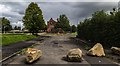
1
Miles Platting
Housing development at Miles Platting.
Image: © Peter McDermott
Taken: 17 Jul 2018
0.02 miles
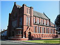
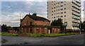
3
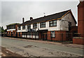
Corpus Christi Church, Miles Platting
On Varley Street, with the attached social club in front.
Image: © Bill Boaden
Taken: 17 Jun 2010
0.02 miles
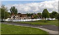
4
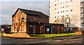
Miles Platting
Events venue at Miles Planning
Image: © Peter McDermott
Taken: 17 Jul 2018
0.03 miles
5
Miles Platting
Housing development at Miles Platting.
Image: © Peter McDermott
Taken: 17 Jul 2018
0.06 miles
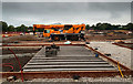
6
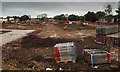
Broadhaven Road
Demolition site on Broadhaven Road.
Image: © Peter McDermott
Taken: 1 May 2017
0.06 miles
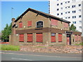
8
The Apollo
The Apollo public house at Miles Platting.
Image: © Peter McDermott
Taken: 27 Dec 2014
0.09 miles
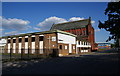
9
The Apollo
The Apollo public house at Miles Platting.
Image: © Peter McDermott
Taken: 31 Aug 2017
0.09 miles