IMAGES TAKEN NEAR TO
George Stringer V C Drive, MANCHESTER, M40 7XF
Introduction
This page details the photographs taken nearby to George Stringer V C Drive, M40 7XF by members of the Geograph project.
The Geograph project started in 2005 with the aim of publishing, organising and preserving representative images for every square kilometre of Great Britain, Ireland and the Isle of Man.

There are currently over 7.5m images from over14,400 individuals and you can help contribute to the project by visiting https://www.geograph.org.uk
Image Map
Images are licensed for reuse under creativecommons.org/licenses/by-sa/2.0
Notes
- Clicking on the map will re-center to the selected point.
- The higher the marker number, the further away the image location is from the centre of the postcode.
Image Listing (111 Images Found)
Images are licensed for reuse under creativecommons.org/licenses/by-sa/2.0
Image
Details
Distance
1
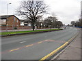
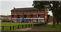
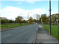
Miles Platting - Oldham Road
The southernmost portion of the main A62 out of Manchester is pictured at the boundary between Ancoats and Miles Platting, near Butler Lane. Neither is a good place to stroll around at quiet times of day.
Image: © Peter Whatley
Taken: 28 Feb 2009
0.06 miles
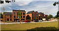
2
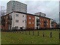
New blocks and old blocks, Butler Street
Image: © David Martin
Taken: 20 Nov 2012
0.08 miles
3
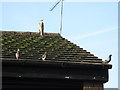
We're not scared!
Seen on Oldham Road. A grey heron looms over various pigeons which might be expected to be wary. Mancunian pigeons are made of sterner stuff.
Image: © Peter Whatley
Taken: 21 Jan 2011
0.09 miles
4
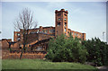
Lloydsfield Mill
Late 19th century cotton mill now in other uses. I have deduced the location and mill name from its position in the slide box, satellite imagery, google, multimap and "Textile mills in Greater Manchester". Please correct me if I've screwed up.
Image: © Chris Allen
Taken: 7 Jun 1992
0.09 miles
5
Medway Walk
Shops and disused flats at Medway Walk in Miles Platting.
Image: © Peter McDermott
Taken: 22 Aug 2015
0.10 miles
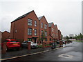
6
Lower Vickers Street
New houses on Lower Vickers Street.
Image: © Peter McDermott
Taken: 1 Jul 2018
0.11 miles
8
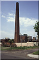
Chimney, Lloydsfield Mill, Miles Platting
Again this is an exercise in deductive reasoning. The slide box is labelled "Miles Platting" and the slide is consecutive with Lloydsfield Mill as I've identified it. The multimap satellite shows a chimney hard by the canal but the google earth image shows cleared ground. The flats behind are still visible on the satellite. I still don't take adequate notes but these days they're on Geograph while the memory is fresh.
Some people would consider the above as superfluous "trumpet blowing" - I regard it as interesting background!
Image: © Chris Allen
Taken: 7 Jun 1992
0.12 miles
10
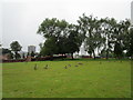
Canada Geese by the Rochdale Canal
Image: © Jonathan Thacker
Taken: 27 Jul 2020
0.14 miles