IMAGES TAKEN NEAR TO
Birt Street, MANCHESTER, M40 7UP
Introduction
This page details the photographs taken nearby to Birt Street, M40 7UP by members of the Geograph project.
The Geograph project started in 2005 with the aim of publishing, organising and preserving representative images for every square kilometre of Great Britain, Ireland and the Isle of Man.

There are currently over 7.5m images from over14,400 individuals and you can help contribute to the project by visiting https://www.geograph.org.uk
Image Map
Images are licensed for reuse under creativecommons.org/licenses/by-sa/2.0
Notes
- Clicking on the map will re-center to the selected point.
- The higher the marker number, the further away the image location is from the centre of the postcode.
Image Listing (38 Images Found)
Images are licensed for reuse under creativecommons.org/licenses/by-sa/2.0
Image
Details
Distance
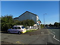
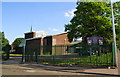
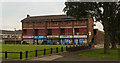
2
Osborne Yard
The 'Osborne Yard' development on Oldham Road.
Image: © Peter McDermott
Taken: 3 Sep 2024
0.02 miles
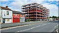
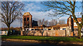
3
Victoria Mill, Miles Platting, Manchester
A former cotton mill, now converted into residential, business and educational premises. SJ858993.
Image: © Keith Williamson
Taken: 13 Apr 2005
0.03 miles
6
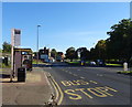
Bus stop and shelter on Oldham Road (A62)
Looking north east.
Image: © JThomas
Taken: 25 Sep 2018
0.09 miles
7

Oldham Road
Billboard on Oldham Road.
Image: © Peter McDermott
Taken: 22 Aug 2015
0.09 miles
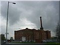
8
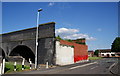
A railway comes to an abrupt end
This was a former goods branch.
Image: © Bill Boaden
Taken: 17 Jun 2010
0.11 miles
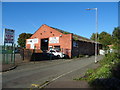
9
Oldham Road
Derelict buildings on Oldham Road.
Image: © Peter McDermott
Taken: 27 Dec 2014
0.12 miles
10
Medway Walk
Shops and disused flats at Medway Walk in Miles Platting.
Image: © Peter McDermott
Taken: 22 Aug 2015
0.13 miles