IMAGES TAKEN NEAR TO
Dalbury Drive, MANCHESTER, M40 7SR
Introduction
This page details the photographs taken nearby to Dalbury Drive, M40 7SR by members of the Geograph project.
The Geograph project started in 2005 with the aim of publishing, organising and preserving representative images for every square kilometre of Great Britain, Ireland and the Isle of Man.

There are currently over 7.5m images from over14,400 individuals and you can help contribute to the project by visiting https://www.geograph.org.uk
Image Map
Images are licensed for reuse under creativecommons.org/licenses/by-sa/2.0
Notes
- Clicking on the map will re-center to the selected point.
- The higher the marker number, the further away the image location is from the centre of the postcode.
Image Listing (93 Images Found)
Images are licensed for reuse under creativecommons.org/licenses/by-sa/2.0
Image
Details
Distance
1
Collyhurst, Church of the Saviour
Anglican church on Phelan Close: http://www.thesaviour.org.uk/
Image: © Mike Faherty
Taken: 26 Dec 2014
0.08 miles
2
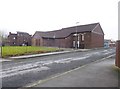
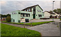
Collyhurst Village
The 'Collyhurst Village' development.
Image: © Peter McDermott
Taken: 2 Sep 2024
0.09 miles
3
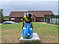
Collyhurst Comb, Church of the Saviour
Bee#96 on the "Bee in the City" sculpture trail is "Collyhurst Comb" with a design that centres around the city's skyline and its radical history. It is set in front of the Church of the Saviour which was founded in 1972 when all the Church of England churches in Collyhurst and Monsall were amalgamated into a new benefice of the Church of the Saviour. The church was established on part of the site formerly occupied by St Oswald's Church on Rochdale Road. This is an evangelical Church of England church.
Image: © David Dixon
Taken: 15 Aug 2018
0.09 miles
4
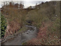
River Irk, Collyhurst
View from the bridge at Smedley Lane.
Image: © David Dixon
Taken: 19 Mar 2012
0.09 miles
5
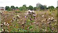
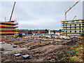
Derelict land off Rochdale Road
No doubt more houses will built here in due course. Meanwhile the thistles have full reign.
Image: © Gerald England
Taken: 27 Jun 2023
0.09 miles
6
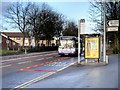
Bus Stop on Rochdale Road
First Manchester Volvo B10BLE/Wright Renown 60369 (R579 SBA), on its journey towards Manchester, passes the bus stop on Rochdale Road in Collyhurst, near the war memorial.
Image: © David Dixon
Taken: 30 Jan 2015
0.09 miles
7
The Vine
The Vine public house in Collyhurst.
Image: © Peter McDermott
Taken: 21 Jul 2020
0.10 miles
9
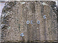
War Memorial Dedication at The Church of the Saviour
The inscription (which is barely legible) reads:
OUR
GLORIOUS
DEAD
1914 1919
See Image] for the wider view.
Image: © David Dixon
Taken: 15 Aug 2018
0.11 miles
10
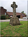
World War I Memorial, Church of the Saviour
Simple stone Celtic Cross standing in the grounds of the Church of the Saviour. It was originally in the churchyard of St Oswald's Church (now demolished). The inscription (which is barely legible) reads:
OUR
GLORIOUS
DEAD
1914 1919
See Image]
Image: © David Dixon
Taken: 15 Aug 2018
0.11 miles