IMAGES TAKEN NEAR TO
Lower Vickers Street, MANCHESTER, M40 7LX
Introduction
This page details the photographs taken nearby to Lower Vickers Street, M40 7LX by members of the Geograph project.
The Geograph project started in 2005 with the aim of publishing, organising and preserving representative images for every square kilometre of Great Britain, Ireland and the Isle of Man.

There are currently over 7.5m images from over14,400 individuals and you can help contribute to the project by visiting https://www.geograph.org.uk
Image Map
Images are licensed for reuse under creativecommons.org/licenses/by-sa/2.0
Notes
- Clicking on the map will re-center to the selected point.
- The higher the marker number, the further away the image location is from the centre of the postcode.
Image Listing (122 Images Found)
Images are licensed for reuse under creativecommons.org/licenses/by-sa/2.0
Image
Details
Distance
1
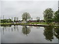
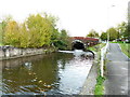
Park improvements, Miles Platting
New benches and new trees on the north bank of the Rochdale Canal.
Image: © Christine Johnstone
Taken: 8 May 2014
0.03 miles
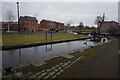
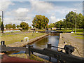
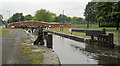
3
Butler Lane Lock, Rochdale Canal, Manchester
Image: © Alexander P Kapp
Taken: 25 Oct 2011
0.03 miles
5
Rochdale Canal below Butler Lane Lock, Manchester
Image: © Alexander P Kapp
Taken: 25 Oct 2011
0.03 miles
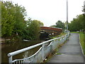
7
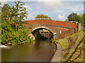
Rochdale Canal, Royle Bridge
Bridge#86 on the Rochdale Canal.
Image: © David Dixon
Taken: 29 Sep 2012
0.03 miles
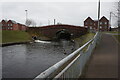
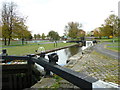
10
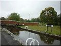
Lock #81, Butler Lane Lock on the Rochdale Canal
Image: © Ian S
Taken: 20 Sep 2011
0.03 miles