IMAGES TAKEN NEAR TO
M40 7LP
Introduction
This page details the photographs taken nearby to M40 7LP by members of the Geograph project.
The Geograph project started in 2005 with the aim of publishing, organising and preserving representative images for every square kilometre of Great Britain, Ireland and the Isle of Man.

There are currently over 7.5m images from over14,400 individuals and you can help contribute to the project by visiting https://www.geograph.org.uk
Image Map
Images are licensed for reuse under creativecommons.org/licenses/by-sa/2.0
Notes
- Clicking on the map will re-center to the selected point.
- The higher the marker number, the further away the image location is from the centre of the postcode.
Image Listing (41 Images Found)
Images are licensed for reuse under creativecommons.org/licenses/by-sa/2.0
Image
Details
Distance
1
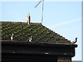
We're not scared!
Seen on Oldham Road. A grey heron looms over various pigeons which might be expected to be wary. Mancunian pigeons are made of sterner stuff.
Image: © Peter Whatley
Taken: 21 Jan 2011
0.07 miles
4
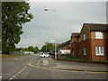
Miles Platting - Oldham Road
The southernmost portion of the main A62 out of Manchester is pictured at the boundary between Ancoats and Miles Platting, near Butler Lane. Neither is a good place to stroll around at quiet times of day.
Image: © Peter Whatley
Taken: 28 Feb 2009
0.09 miles
5
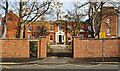
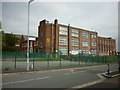
St. Patrick's
The nunnery at St. Patrick's Roman Catholic Church & School.
Image: © Peter McDermott
Taken: 19 Nov 2021
0.09 miles
6
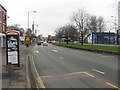
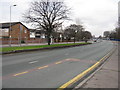
Butler Street Junction, Oldham Road, Manchester
The A62 passes without ceremony from Miles Platting to Ancoats at this point.
Image: © Peter Whatley
Taken: 28 Feb 2009
0.10 miles
7
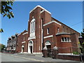
St Patrick's Catholic Church, Collyhurst
St Patrick's Roman Catholic Church dominates Livesey Street in Collyhurst. Pevsner describes it as Romanesque in style with Art Deco influences. This wasn't the first St. Patrick's Church on the site. The first church was built in 1832 but this one dates from 1937.
Image: © Neil Theasby
Taken: 2 Jun 2016
0.13 miles
8
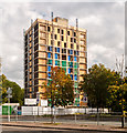
Rodney Court
Redevelopment of Rodney Court (Image]), a block of flats off Oldham Road.
Image: © Peter McDermott
Taken: 28 Sep 2014
0.14 miles
9
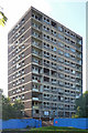
Rodney Court, Oldham Road, Manchester
A derelict 1960s tower block which, according to the hoardings, is being converted to bijou apartments by trendy urban developers Urban Splash. Work appeared to have stalled (if it ever started), which has presented an opportunity for trendy pigeons seeking (at a stretch) city-centre living.
Image: © Stephen Richards
Taken: 24 Jul 2011
0.14 miles
10
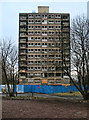
Rodney Court
Derelict flats at Wadeford Close.
Image: © Peter McDermott
Taken: 16 Mar 2013
0.14 miles