IMAGES TAKEN NEAR TO
Thornton Street, MANCHESTER, M40 7GL
Introduction
This page details the photographs taken nearby to Thornton Street, M40 7GL by members of the Geograph project.
The Geograph project started in 2005 with the aim of publishing, organising and preserving representative images for every square kilometre of Great Britain, Ireland and the Isle of Man.

There are currently over 7.5m images from over14,400 individuals and you can help contribute to the project by visiting https://www.geograph.org.uk
Image Map
Images are licensed for reuse under creativecommons.org/licenses/by-sa/2.0
Notes
- Clicking on the map will re-center to the selected point.
- The higher the marker number, the further away the image location is from the centre of the postcode.
Image Listing (52 Images Found)
Images are licensed for reuse under creativecommons.org/licenses/by-sa/2.0
Image
Details
Distance
1
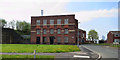
Telephone Exchange
Collyhurst Telephone Exchange on Ryder Street.
Image: © Peter McDermott
Taken: 21 Apr 2014
0.01 miles
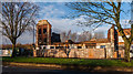
3
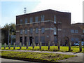
Collyhurst Telephone Exchange
The telephone exchange building on Thornton Street.
Image: © David Dixon
Taken: 28 Sep 2011
0.02 miles
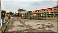
6
Oldham Road
Derelict buildings on Oldham Road.
Image: © Peter McDermott
Taken: 27 Dec 2014
0.08 miles
7
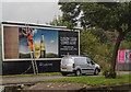
Oldham Road
Billboard on Oldham Road.
Image: © Peter McDermott
Taken: 22 Aug 2015
0.08 miles
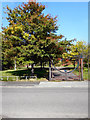
9
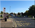
Bus stop and shelter on Oldham Road (A62)
Looking north east.
Image: © JThomas
Taken: 25 Sep 2018
0.09 miles
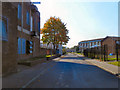
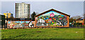
10
Collyhurst South
The 'Collyhurst South' development.
Image: © Peter McDermott
Taken: 2 Sep 2024
0.11 miles